The Road to Olinghouse
Is Olinghouse Road a Public Road?
Copyright 2022
Jed Margolin
June 30, 2022
The short answer is Yes. The evidence shows that Olinghouse Road is a public road all the way from the old town of Olinghouse to SR 447. And it is a ride through Nevada history.
Why It Matters to Me
You might be wondering why I care if Olinghouse Road is a public road. The answer is:
1. NextEra Energy/Dodge Flat Solar wants people to believe that Olinghouse Road is Not a public Road; and
2. I own property that is accessible only by Olinghouse Road (or by air).
If you want to focus only on Olinghouse Road and skip all of Nevada’s interesting history Click Here.
Index
Part 1 - How Nevada became a State
Part 2 - Happy Trails to Oregon and then Happy Trails to California by way of Nevada
Part 3 - The Transcontinental Railroad
Part 4 - Money and Land Grants
Part 5 - Olinghouse and Its Road
Part 6 - More Maps - One is by the U.S. Geological Survey dated 1915, the other is the General Highway Map, Washoe County Nevada, Prepared by the Nevada State Highway Department, 1947.
Part 7 - More Evidence
Part 8 - The Loxodonta africana in the Room
The Road to Olinghouse
Is Olinghouse Road a Public Road?
Part 1 - How Nevada became a State
When Christopher Columbus (an Italian sailing for Spain) came to the Americas in 1492 he did not discover America. America was already here and there were already people living here, the Native Americans. They discovered America first.
Columbus was not even the first European to come to the Americas.
From http://www.let.rug.nl/usa/outlines/history-1994/early-america/the-first-europeans.php)
The first Europeans to arrive in North America -- at least the first for whom there is solid evidence -- were Norse, traveling west from Greenland, where Erik the Red had founded a settlement around the year 985. In 1001 his son Leif is thought to have explored the northeast coast of what is now Canada and spent at least one winter there.
The Norse didn’t stay.
There might have been other Europeans but presumably they died, didn’t stay, or they assimilated themselves into the Native American tribes and failed to leave behind accepted evidence of their existence.
But after Columbus the European nations claimed the Americas as their property: Spain, Great Britain, France, Portugal, and the Netherlands (think New Amsterdam which became New York after the British took it from them). Germany did not participate in this colonization because Germany did not become a nation state until 1871 when Otto von Bismark united the several small German states to become a nation. By then all of the good stuff around the world had already been claimed.
Spain claimed huge areas of the Americas including what is now Mexico. That included a large part of what is now the Western United States.
Mexico fought for and won its independence from Spain in the Mexican War of Independence (1810 –1821).
Later, as a result of the Texas Revolution (October 2, 1835 – April 21, 1836) the Texas province broke away from Mexico and became an independent country. Remember the Alamo?
In 1845 Texas became part of the United States. However, Mexico still considered Texas to be Mexican territory and this led to the Mexican-American War (1846 - 1848). Mexico lost. And they lost more than Texas. The white areas in the following map are what they lost in the Treaty of Guadalupe Hidalgo:
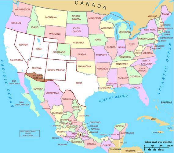
See https://www.archives.gov/milestone-documents/treaty-of-guadalupe-hidalgo
The map shows the current states but that is not how it started out.
From: https://en.wikipedia.org/wiki/Territorial_evolution_of_the_United_States#1845%E2%80%931860_(Southwest_expansion)
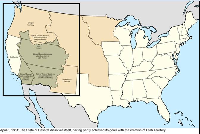
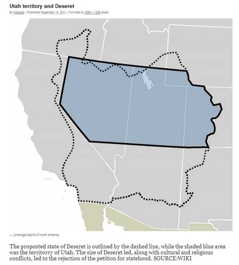
A local government formed the State of Deseret and claimed a vast portion of the southwest, including most of the Mexican Cession. Though it petitioned to be admitted to the United States, the proposal was rejected and, in 1850, Utah Territory was formed instead.[191] The claimed area overlapped slightly with Texas' claimed area, as well as part of Oregon Territory.
Here is some important history: Faced with deadly persecution in the United States the Mormons under the leadership of Brigham Young left the United States for Mexico and founded Salt Lake City so they could safely practice their religion. But because of the Treaty of Guadalupe Hidalgo they were in the United States again. They didn’t cross the border, the border crossed them
One of the reasons the State of Deseret was not admitted to the Union was because they refused to give up polygamy. Indeed, they were told that they would never be made a state until and unless they did that.
The United States carved up the Utah Territory until it was reduced to the size of the current state of Utah. Then the Mormons gave in and made polygamy illegal and Utah was made a state. But this did not happen until 1896 when Utah became the 45th state.
Note that in 2020 Utah changed polygamy from a felony to an infraction. See https://www.nytimes.com/2020/05/13/us/utah-bigamy-law.html.
Murdering someone is a felony. Drunk driving is at least a misdemeanor. A parking ticket is an infraction. They did this during the first wave of the Covid-19 Pandemic which is probably why it went largely unnoticed.
Now from the History of Washoe County PDF page 6:
On January 14, 1857, Carson County was attached to Great Salt Lake County for election, revenue and judicial purposes, although the two counties did not form a contiguous territory. The same year, President John Buchanan ordered a small army under Colonel (later General) Albert Sydney Johnston to Salt Lake City to reestablish the Federal Government's supremacy over the Mormons.41
Apprehensive of the army's purpose, Brigham Young in calling his Saints from western Utah and elsewhere to defend Salt Lake City wrote "We have concluded that it is wisdom that you should dispose of your property as well as you can and come home. *** Come in one company, and keep together so that you can protect yourselves against all foes, both red and white."42 Obediently, on September 26, 1857, the Mormons of Washoe Valley abandoned their farms and returned to Salt Lake City.43 Most of the adherents of Brigham Young withdrew from the section now called Nevada, leaving as residents of Carson County only Gentiles and those who repudiated the authority of Brigham Young.
After the departure of the Mormons in 1857, John F Stone and Charles C Gates conducted a trading post on the Truckee River (formerly called Jamison's Station), which was afterward known as Stone and Gates Crossing and later as Glendale.44
Western Utah in 1859 remained a sparsely settled country. A reorganization of Carson County detaching it from Great Salt Lake County proved only partially successful, leaving the section practically without political organization. In the spring of 1859, C W. Fuller, a Honey Lake rancher, established Fuller's Station on the Truckee River, the present site of Reno.45 The Comstock Lode was discovered in June 1859. The whole region between the Sierra Nevada and Salt Lake City came to be known to the outside world as Washoe. "History records few migrations of men equal to that produced by the discovery of the Comstock Lode. The placer mines of California had begun to fail and the Washoe excitement captured the coast and a tide of men poured over the Sierra Nevada range in a perfect torrent."46
And from PDF page 7:
In November 1860, Governor Alfred W Cumming of the Territory of Utah, recognizing the inability of Utah to maintain a stable government for the western region, said in a message to the Utah legislative assembly:
The population of the western portion of this Territory, known as Nevada, has recently become much more numerous, in consequence of the influx of a large number of persons, attracted by the mineral wealth of that region. The vast extent of uninhabited country which separate [sic] these valleys from those of Sierra Nevada, renders intercourse between them very inconvenient, and makes it very probable that the latter will receive a separate Territorial organization from the Government, so soon as the increased population shall have become permanent, and sufficiently large to justify the United States in granting their request for one.51
Four months later on March 2, 1861, the Congress created the Territory of Nevada,52 and in July 1861 Governor James W Nye proclaimed that the territory was organized. Washoe County's population was then estimated at 1,613. 53
The first legislative assembly convened October 1, 1861, at Carson City. By an act approved November 25, 1861, 54 the Territory of Nevada was divided into nine counties. 55
The History of Washoe County is available here: https://www.washoecounty.gov/clerks/cco/code/history.pdf
For a local copy Click Here.
It was written by Russell W. McDonald in 1982. Russell West McDonald was a member of the Greatest Generation. After serving in the Navy during the Second World War he made significant contributions to Nevada, here as an historian. After he passed in 1995 the Nevada Assembly gave him a nice tribute in an Assembly Concurrent Resolution: https://www.leg.state.nv.us/Session/68th1995/95bills/ACR35.TXT
Let’s go back to Governor Cumming’s statement:
The population of the western portion of this Territory, known as Nevada, has recently become much more numerous, in consequence of the influx of a large number of persons, attracted by the mineral wealth of that region.
He was talking about Storey County. From the Storey County Master Plan (retrieved circa 2007) starting on PDF page 3:
1.3 History of Storey County
The unprecedented wealth of the Comstock Lode virtually created Virginia City and Storey County. The following account gives a historical outline of Storey County:
One of the most famous mining camps in the world, Virginia City was established in 1859 after the discovery of the Comstock Lode. The mining camp was named in honor of James "Old Virginny" Finney by the early prospectors because of his discovery and knowledge of placers below what would later be the Ophir Mine and his location of the first quartz mining claim on the Comstock.
Virginia City, county seat of Storey County, is on the east side of the Virginia Range just below Mountain Davidson at an elevation of 6,220 feet. Today Virginia City is a year-round international tourist attraction with a population of about 700.
In the fall of 1859, Virginia City had an initial population of between 200 to 300. After word of the Comstock discovery in early 1860, perhaps 10,000 rushed to the Comstock, many from the California goldfields.
About 4,000 remained in the area: 2,345 in Virginia City (868 dwellings), the rest in Gold Hill and vicinity. The political ramifications resulted in the creation of the Nevada Territory, carved from Utah Territory, by President Buchanan on March 2, 1861.
The population remained about 4,000 through 1862. Samuel Clemens arrived in late 1862, worked as a reporter for the Territorial Enterprise for 21 months, and left as Mark Twain. During this period construction of the old Geiger Grade Toll Road was started and in partial use by the end of the year. This road linked Virginia City with emigrant trails and supply routes that crossed the Truckee River at the site that would become Reno in 1868. Organization of the San Francisco Stock Exchange Board, the first mining exchange in the United States, also occurred in 1862.
By 1863, mining successes and promotion brought the Virginia City and vicinity population to some 15,000. Homes, business buildings and office blocks were built, gas and sewer pipes were laid in the principal main streets. Daily stages brought in all the luxuries of the Bay Area. The town was made up of two classes of people, each of which kept its own place and went its way without interference from the other. Seventy-five stamp-amalgamation mills were operating in the region: 19 in Virginia City and in Six and Seven Mile canyons below, 35 in Gold Canyon from Gold Hill to Dayton, 12 on the Carson River, and nine in Washoe Valley.
The Comstock brought enough people, money and politicians to the area that on October 31, 1864, Nevada was admitted as the 36th State. Economic slow-down saw 10,000 leave the area, many for other mining camps, leaving an area population of about 4,000 in 1865. Virginia City population increased to about 11,000 by 1868. The Yellow Jacket Mine fire occurred in 1869, which also saw the construction of the Virginia and Truckee Railroad between Virginia City and Carson City and Reno was completed on August 24, 1872, linking up with the existing Central Pacific Railroad. This pretty much ended the wagon freight business over the Sierra and to Virginia City.
......
Between 1873 and 1874, the population of the area exploded to 25,000 in Virginia City and 5,000 in Gold Hill as the result of the discovery of the Bonanza ore body in the Con. Virginia Mine and extending into the California Mine.
Wikipedia has a good entry for Virginia City. https://en.wikipedia.org/wiki/Virginia_City,_Nevada
Governor Cumming could see that if Nevada remained as part of the Utah Territory Utahns would lose their political power so he did the sensible thing and recommended that Nevada be cut loose from the Utah Territory.
Then President Abraham Lincoln needed the revenue from the silver to finance the Civil War. That is why he pushed through the bill making Nevada a state. Nevada became the 36th state on October 31, 1864.
That is how Nevada became a state.
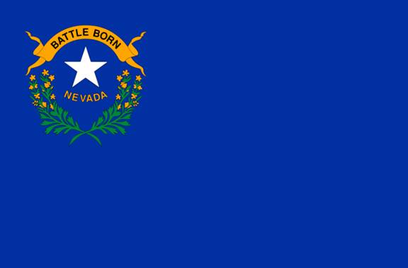
Nevada also contributed men to fight for the Union.
That is why the Nevada state flag says “Battle Born”.
Now for a bonus.
When Nevada became a state Virginia City was the largest city in Nevada. The population of Carson City was much smaller (the number of people, not how big they were). The area that later became the city of Reno was a trading post and river crossing on the Truckee River. Las Vegas did not yet exist.
At one time Virginia City was the largest city between Denver and San Francisco.
The Comstock made several millionaires. A million dollars in 1861 would be equivalent to 32 million dollars today. https://www.officialdata.org/us/inflation/1861?amount=1000000
The money from the Comstock built San Francisco.
One of the Comstock millionaires was Adolph Sutro who built the Sutro Tunnel to drain the hot spring waters in the mines under Virginia City to the valley below. It begins at the Savage Mine in Virginia City and goes down the mountain to near Dayton. Sutro went on to become the 24th mayor of San Francisco. https://en.wikipedia.org/wiki/Adolph_Sutro
Some were more than millionaires, like John Mackay. https://en.wikipedia.org/wiki/John_William_Mackay
He was worth more than $50 Billion in today’s money.
One of the things he did with his money, in addition to giving to the School of Mines at the University of Nevada, was to help build a second Transatlantic Cable. Before then Western Union, which owned the one and only Transatlantic Cable, was controlled by Jay Gould, one of the great Robber Barons of the 19th Century.
The competition from the second cable brought down the cost of sending a transatlantic telegram from $5/word to $0.25/word (in 1880s money). The U.S. Census Bureau issued a report in 1957 that contained the following historical information:
https://www2.census.gov/library/publications/1960/compendia/hist_stats_colonial-1957/hist_stats_colonial-1957-chR.pdf
In the following, the Western Union Telegraph Company was controlled by Jay Gould, the Commercial Cable Company was John Mackay’s company, and back then the term “cable company” had nothing to do with TV and Internet.
On PDF page 8:
R 86-89. International cable and radiotelegraph rates between New York City and selected cities, 1866-1956.
Source: 1866-1928, scattered sources as indicated below; 1929-1956, FCC, records. New York to London.
The first successful transatlantic cable was laid in 1866. James D. Reid, The Telegraph in America (1886), p. 748, indicates that the first telegraph rate on the cable (presumably New York to London) was $100 for 10 words. Three months later, the same source states, the rate was reduced to $50 and subsequently to $25.
By 1868, the rate for 10 words had declined to $15.75, and in 1885 it stood at 40 cents per word. A staff document of American Cable & Radio, Inc., prepared in connection with FCC Docket No. 8777 (1948) indicates that the Western Union Telegraph Company had a 50 cents per word rate in 1884, and that on December 24 of that year the Commercial Cable Company entered the field with a rate of 40 cents per word. The same source indicates that the cable companies other than Commercial Cable reduced their rates to 12 cents per word on May 6, 1886, and Commercial Cable in turn lowered its per word rate from 40 cents to 25 cents. On September 16, 1887, Commercial Cable further reduced its rate to the 12 cent level. Then on September 1, 1888, all the cable companies raised their rate between New York and London to 25 cents per word.
Part 2 - Happy Trails to Oregon and then Happy Trails to California by way of Nevada
The Oregon Trail
From https://en.wikipedia.org/wiki/Oregon_Trail
In 1803, President Thomas Jefferson issued the following instructions to Meriwether Lewis: "The object of your mission is to explore the Missouri river, & such principal stream of it, as, by its course & communication with the waters of the Pacific Ocean, whether the Columbia, Oregon, Colorado and/or other river may offer the most direct & practicable water communication across this continent, for the purposes of commerce."[2] Although Lewis and William Clark found a path to the Pacific Ocean, it was not until 1859 that a direct and practicable route, the Mullan Road, connected the Missouri River to the Columbia River.[3]
Here is the map.
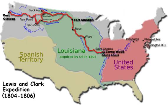
The United States ended at the Mississippi River and even so, several states had not become states at that point. Maine became the 23rd state in 1820. The Michigan Territory was formed in 1805 but some of the northern border with Canada was not agreed upon until after the War of 1812. Michigan was admitted into the Union in 1837 as the 26th state. Minnesota was not yet a state either. It was admitted to the Union in 1858 as the 32nd state.
Notice that there are no states west of the Mississippi and there is that large section called Louisiana. Say what?
From https://en.wikipedia.org/wiki/Louisiana_Purchase
The Kingdom of France had controlled the Louisiana territory from 1699 until it was ceded to Spain in 1762. In 1800, Napoleon, the First Consul of the French Republic, regained ownership of Louisiana as part of a broader project to re-establish a French colonial empire in North America. However, France's failure to put down a revolt in Saint-Domingue, coupled with the prospect of renewed warfare with the United Kingdom, prompted Napoleon to consider selling Louisiana to the United States. Acquisition of Louisiana was a long-term goal of President Thomas Jefferson, who was especially eager to gain control of the crucial Mississippi River port of New Orleans. Jefferson tasked James Monroe and Robert R. Livingston with purchasing New Orleans. Negotiating with French Treasury Minister François Barbé-Marbois (who was acting on behalf of Napoleon), the American representatives quickly agreed to purchase the entire territory of Louisiana after it was offered. Overcoming the opposition of the Federalist Party, Jefferson and Secretary of State James Madison persuaded Congress to ratify and fund the Louisiana Purchase.
The Louisiana Purchase extended United States sovereignty across the Mississippi River, nearly doubling the nominal size of the country. The purchase included land from fifteen present U.S. states and two Canadian provinces, including the entirety of Arkansas, Missouri, Iowa, Oklahoma, Kansas, and Nebraska; large portions of North Dakota and South Dakota; the area of Montana, Wyoming, and Colorado east of the Continental Divide; the portion of Minnesota west of the Mississippi River; the northeastern section of New Mexico; northern portions of Texas; New Orleans and the portions of the present state of Louisiana west of the Mississippi River; and small portions of land within Alberta and Saskatchewan.
The Louisiana Purchase was approved by Congress in December 1803. The price was $15M. The American government did not have $15M so it used $3 million in gold as a down payment, forgave $3.75 million in French debt, and borrowed the rest from European banks at an interest rate of 6%.
Here is more information about the Louisiana Purchase. https://www.history.com/news/8-things-you-may-not-know-about-the-louisiana-purchase
France had claimed the Louisiana territory under the reign of Louis XIV. https://en.wikipedia.org/wiki/Louis_XIV
French colonies multiplied in Africa, the Americas, and Asia during Louis' reign, and French explorers made important discoveries in North America. In 1673, Louis Jolliet and Jacques Marquette discovered the Mississippi River. In 1682, René-Robert Cavelier, Sieur de La Salle, followed the Mississippi to the Gulf of Mexico and claimed the vast Mississippi basin in Louis' name, calling it Louisiane
In going from French to English it became Louisiana.
Now back to the Oregon Trail. Although it did not directly affect Nevada yet (that area was still claimed by Spain) it did show that if you were motivated enough you could overcome difficult terrain like rivers, mountains, and canyons and make a trail to take you to wherever you wanted to go. There was still the problem that sometimes you met Native American tribes who did not welcome intruders (especially immigrants) on their land.
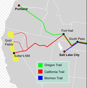
The California Emigrant Trail
People started using the California Emigrant Trail (the California Trail) as early as 1841 when the Bidwell-Bartleson party started near Independence, Missouri and made it all the way to California. Read about it here: https://www.nps.gov/cali/learn/historyculture/index.htm
The California Trail became much more popular after gold was discovered in California in 1848 setting off the California Gold Rush. From https://en.wikipedia.org/wiki/California_Gold_Rush
The California Gold Rush (1848–1855) was a gold rush that began on January 24, 1848, when gold was found by James W. Marshall at Sutter's Mill in Coloma, California.[1] The news of gold brought approximately 300,000 people to California from the rest of the United States and abroad.[2]
.....
Outside of California, the first to arrive were from Oregon, the Sandwich Islands (Hawaii), and Latin America in late 1848. Of the approximately 300,000 people who came to California during the Gold Rush, about half arrived by sea and half came overland on the California Trail and the Gila River trail; forty-niners often faced substantial hardships on the trip. While most of the newly arrived were Americans, the gold rush attracted thousands from Latin America, Europe, Australia, and China.
The following about the California Trail comes from the California Trail Interpretive Center, Elko, Nevada. https://www.californiatrailcenter.org/ This reference is not very long. It is nicely written and it is worth reading the whole thing. https://www.californiatrailcenter.org/wp-content/uploads/California-Trail-History.pdf .
The decision to head west was difficult. On one hand, leaving meant saying goodbye to friends, family, the familiar, and the United States; on the other, emigrants would be experiencing new adventures and the allure of the west. After 1848, gold lured many, but it wasn’t the only reason to venture to California. People came for reasons including economics, adventure, health, and ideas like Manifest Destiny.
.....
After deciding to leave, the emigrants faced the decision on how to travel. There were many routes west but most people traveled on overland trails, including the California and Oregon Trails. Both trails were roughly 2000 miles, depending on the various routes and cutoffs chosen and would take a typical emigrant family 3-6 months to make this journey. Although it is estimated that over 250,000 people traveled upon the California Trail, it is often overshadowed by the less-traveled Oregon Trail. Both trails follow the same route until Idaho, where the Oregon Trail heads west, and California Trail branches south. Emigrants encountered some of the harshest terrain after the divergence of the California Trail, traveling through the 40 mile desert, east of Reno and then, over the Sierra Nevada.
The California Trail followed the Oregon Trail until Idaho. That is why I discussed the Oregon Trail first.
There is also the part, “and that emigrants encountered some of the harshest terrain after the divergence of the California Trail, traveling through the 40 mile desert, east of Reno and then, over the Sierra Nevada.”
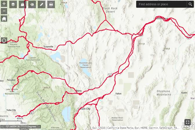
This is a map of the California Emigrant Trail after it left the Oregon Trail in Idaho. It is from https://en.wikipedia.org/wiki/California_Trail
Somewhere around the end of the Humboldt River 22 miles NE of Lovelock it split into several trails.
One went to the north and west to Susanville, then split to either Redding or Red Bluff (all in California).
Two went to the southwest. One went to the Carson River at Carson City, the other went to the Truckee River at what became Wadsworth.
The following maps are from:
https://nps.maps.arcgis.com/apps/webappviewer/index.html?id=24fc463363f54929833580280cc1a751
The California Trail is overlaid with a modern map.
To Carson City:
To Wadsworth:
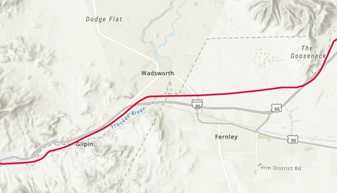
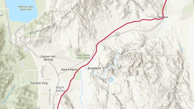
The California Trail came close to Olinghouse Road which came a little later. (Remember, the California Trail is overlaid with a modern map.)
The contrast is not very good. Here is a closeup:
When you are making a trail a good guiding principle is to follow the water. Sometimes that is not possible, like here. Whichever way you went you had to cross the 40 Mile Desert after the Humboldt River ended. This was an extremely dangerous part of the trip. See https://en.wikipedia.org/wiki/Lahontan_Valley#Forty_Mile_Desert
The 40 Mile Desert is in what became Churchill County. (Yes, they still call it the 40 Mile Desert.)
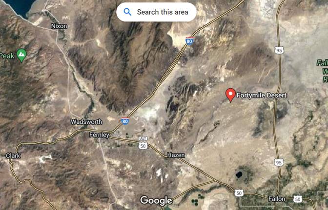
It’s pretty barren. I think it would be a great place for solar farms.
Part 3 - The Transcontinental Railroad
From: https://www.senate.gov/artandhistory/history/common/generic/PacificRailwayActof1862.htm
The rapid settlement of the western territories in the 1850s convinced most members of Congress of the need for efficient rail transport to the Pacific coast, but which route would the railroad follow? In the years leading up to the Civil War, Congress commissioned topographical surveys in an effort to identify the best route. Unfortunately, competition between northern and southern members seeking a route advantageous to their own region prevented the Senate from passing any proposed legislation for a transcontinental railroad. Ironically, only days before bidding farewell to the Senate after Mississippi seceded from the Union, Senator Jefferson Davis expressed his support for the railroad as a symbol of national unity. “I have thought it an achievement worthy of our age and of our people, to couple with bonds of iron the people of the Pacific with the valley of the Mississippi,” he declared, “and show that even snow-capped mountains intervening could not divide them.”
After Southern states seceded, Congress agreed on a northern route to the Pacific and to the use of federal lands to subsidize the construction of a railroad and telegraph line. The Pacific Railway Act, which became law on July 1, 1862, offered government incentives to assist “men of talent, men of character, men who are willing to invest” in developing the nation’s first transcontinental rail line. Authorizing the Union Pacific and the Central Pacific railroad companies to construct the lines, the legislation provided government bonds to help fund the work, in addition to vast land grants. Employing thousands of immigrant workers and facing enormous challenges including harsh weather, massive mountain ranges, and conflicts with Native Americans, each company made its way towards a meeting point that would complete the line. On May 10, 1869, workers drove in the ceremonial “Golden Spike” at Promontory, Utah, joining the two lines.
The legislative efforts that resulted in the Pacific Railway Act led to the successful completion of the transcontinental railroad, which reduced the travel time across the continent from several months to one week and is considered one of the greatest technological achievements of the 19th century.
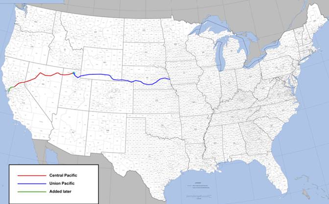
There were actually three routes proposed. The most northern route roughly followed along the Missouri River through present-day northern Montana to the Oregon Territory. The central route followed the Platte River in Nebraska through to the South Pass in Wyoming, following most of the Oregon Trail. The southern route went across Texas, the New Mexico Territory, and the Sonora desert, connecting to Los Angeles, California. Congress chose the central route which they considered a northern route, probably because it did not go through the Confederacy. (Years after the Civil War ended a transcontinental railroad using the southern route was built going from New Orleans to Los Angeles.)
The original copy of the Pacific Railway Act has pretty much faded away so here is the official transcript:
https://www.archives.gov/milestone-documents/pacific-railway-act#transcript
The Pacific Railway Act created the Union Pacific Railroad Company which was charged to:
layout, locate, construct, furnish, maintain, and enjoy a continuous railroad and telegraph, with the appurtenances, from a point on the one hundredth meridian of longitude west from Greenwich, between the south margin of the valley of the Republican River and the north margin of the valley of the Platte River, in the Territory of Nebraska, to the western boundary of Nevada Territory,
and:
there to meet and connect with the line of the Central Pacific Railroad Company of California.
whereby:
The Central Pacific Railroad Company of California, a corporation existing under the laws of the State of California, are hereby authorized to construct a railroad and telegraph line from the Pacific coast, at or near San Francisco, or the navigable waters of the Sacramento River, to the eastern boundary of California,
The Leavenworth, Pawnee, and Western Railroad Company of Kansas was to build the railroad and telegraph line from the Missouri River, at the mouth of the Kansas River, on the south side, to connect with the Pacific railroad of Missouri which was to take it on to Nebraska.
Everyone was to use the same gauge tracks, which was later specified at four feet eight and a half inches. This was the rail gauge used by George Stephenson who built the first practical steam locomotive in England so it was called the Stephenson Gauge. Not everyone used the Stephenson Gauge. Some used a wider gauge. Some did it because a wider gauge made the train more stable. Some did it so their rail system would be incompatible with their competitors. https://railroad.lindahall.org/essays/rails-guage.html
This map of the original route is from Wikipedia. (They left out the smaller railroads from Missouri to Nebraska.)
This is where the Transcontinental Railroad went through Wadsworth. (From http://cprr.org/Museum/Maps/_wadsworth_nv_feb1869_lh.html)
It was drawn by Andrew J. Hatch, Washoe County Surveyor, in 1869.
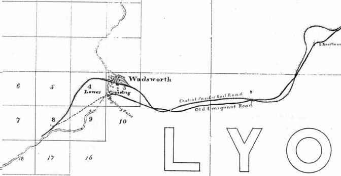
For the entire map as a PDF file Click Here.
Why Wadsworth?
It was because of the technology of steam locomotives.
The steam locomotive is a relatively basic machine. Fuel (originally wood or coal, and then later oil) is fed into the firebox and burned to heat water in the boiler to produce high pressure steam.
This high pressure steam is then fed into cylinders where it moves the pistons and drives the locomotive’s rods (horizontal iron/steel shafts attached to the wheels) propelling it forward. The spent hot gases are then carried into the smoke box where they are funneled towards the smoke stack and out of the locomotive. See https://www.american-rails.com/steam.html#gallery[pageGallery]/0/
The basic idea is shown here: https://en.wikipedia.org/wiki/Steam_locomotive_components
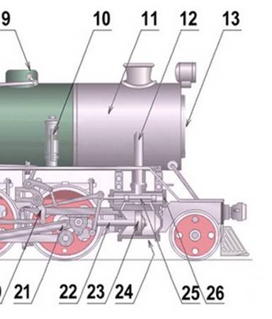
The cylinder is #24, the piston is #23, it connects to the wheel using shaft #22.
The cylinder has valves to let the high pressure steam in at the right time and to let the spent steam out at the right time, just like in a modern gasoline engine in a car (which uses exploding gasoline instead of steam). If this article survives long enough you might never have owned a car with a gasoline engine so you won’t know what I am talking about.
For some famous locomotives see https://www.up.com/customers/track-record/tr042120-steam-to-green-evolution-of-the-locomotive.htm
If you have ever seen a steam locomotive in action (probably in a movie) it produces a lot of smoke and spent steam. If you ever ride a train pulled by a steam locomotive remember to close the windows when you go through a tunnel.
The steam locomotive is an open cycle steam engine. The water is used once and then the spent steam is vented. As a result the engine needs a continuous supply of new water. If you run out of water the firebox will overheat and cause the boiler to explode so the Fireman has two jobs. Keep putting wood (or coal) into the firebox and constantly check that there is enough water going into the boiler. The locomotive also has an Engineer whose job it is to safely get the train from one place to another. Driving a train is harder than you might think, especially back then: http://www.catskillarchive.com/rrextra/engineer.Html
A locomotive can carry only a small amount of fuel and water. In this mode the locomotive would have to stop and take on water about every 7-10 miles (fuel about every 20 miles) so they invented the tender. The tender was a special car right behind the locomotive that carried water and fuel. With a tender the locomotive could go 100-150 miles without refueling. https://en.wikipedia.org/wiki/Water_stop
The actual distance that the locomotive could go before refueling depended on the load it was pulling and the grade. Going up a mountain used fuel faster. (The Laws of Thermodynamics). The need for refueling was one of the reasons for building so many towns (to be explained shortly).
Not all steam engines are open-cycle. In a closed-cycle steam engine the spent steam is collected and sent through a heat exchanger that cools the spent steam down to the ambient temperature where it condenses to become water again. Then you start the process all over again.
This is what modern nuclear power plants do. They use a nuclear fission reactor to produce heat that turns the working fluid into a high pressure gas which goes to a gas turbine. (The turbine is more efficient than a reciprocating engine.) The gas turbine then turns a generator and you have electricity. The spent gas then goes to a heat exchanger to turn the working fluid back to a liquid. That is what the huge cooling tower is. It’s a heat exchanger.
When someone comes up with a practical nuclear fusion reactor that is how it will be used to produce electricity. At least until someone figures out how to produce electricity directly from a fusion reactor. Maybe by accelerating ions to near light-speed. Put a coil around the accelerating ion beam to harvest some of the energy. Harvest more of the energy by having the ion beam hit a metal plate to produce an electrical current.
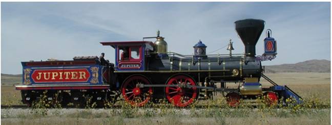
When the Central Pacific Railroad joined their tracks with the Union Pacific at Promontory Point, Utah in 1869 to complete the Transcontinental Railroad the Central Pacific used their Jupiter locomotive (Engine No. 60).
The Union Pacific used their Engine No. 119.
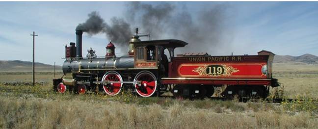
Note that both locomotives used tenders. The pictures are from: https://www.nps.gov/gosp/learn/historyculture/everlasting-steam-the-story-of-jupiter-and-no-119.htm
If you are interested in steam locomotive nomenclature this is an excellent article: https://engineering.fandom.com/wiki/Steam_locomotive_nomenclature . Both the Jupiter and the No. 119 are “4-4-0” locomotives meaning that they have 4 wheels on the pilot truck, 4 driving wheels, and no wheels on the trailing truck. BTW, they have two cylinders, one on each side.
So, the answer to Why Wadsworth is that a locomotive can carry only a small amount of fuel and water. In this mode the locomotive would have to stop and take on water about every 7-10 miles (fuel about every 20 miles) so they invented the tender. The tender is a special car right behind the locomotive that carries water and fuel. With a tender the locomotive could go 100-150 miles without refueling.
That still isn’t a great deal when you have to go through a 40 Mile Desert.
If you are going east the last place to get water is where the Truckee River turns north to go to Pyramid Lake.
That is where and why the Central Pacific built the town of Wadsworth.
Wadsworth is on the Pyramid Lake Paiute Tribe Reservation which was established in 1859. See
https://travelnevada.com/museums/pyramid-lake-paiute-tribe-museum-visitors-center/ and
https://en.wikipedia.org/wiki/Pyramid_Lake_Paiute_Tribe_Reservation
Note that this was before Nevada became a state and was still part of the Utah Territory.
This is how things went for Wadsworth. https://www.nvexpeditions.com/washoe/wadsworth.php
Though a crude trading post may have existed as early as 1854, Wadsworth wasn't established until 1868 when the Central Pacific Railroad created a construction camp near the 'Big Bend' of the Truckee River. Before long, Wadsworth became the headquarters for the Truckee Division and a twenty-stall roundhouse was built, as well as machine shops to rebuild engines. Freight routes were soon developed, connecting far off mining camps like Ellsworth and Columbus to Wadsworth and the town became the most important along the railroad east of Reno.
By the 1870s, Wadsworth contained several stores, hotels, and saloons. In 1871, an attempt was made to become part of Churchill County in an effort to attain the county seat (Wadsworth's population, around 700, outnumbered the entire rest of the county). Wadsworth continued to be successful as a freighting point for years, though in April 1884 a fire wiped out the majority of the facilities (which were subsequently rebuilt).
In 1902, the Central Pacific decided to realign sections of the original route. The realignment eliminated the need for Wadsworth and the community was bypassed. In 1904 all of Wadsworth's facilities were moved to a new location east of Reno (now Sparks), and many businesses and residents relocated not long after. A small hamlet remains, though it too was bypassed by roadway traffic when Interstate 80 was built in the 1960s.
This entry is from a discussion board and was posted 1/4/2020 at https://www.trainorders.com/discussion/read.php?11,4932212
Nostalgia & History > Mr. Harriman wasn't impressed
In 1904 Edward H. Harriman had launched the modernization program of Union Pacific which included the straightening of the Central Pacific line in western Nevada. As a result the original Central Pacific division point at Wadsworth was by-passed. The railroad looked for land closer to the Sierras to build a new terminal with roundhouse and back shop. They first looked at Reno but property there was too expensive so they looked three miles east of Reno and purchased a swampy ranch prone to flooding. There initially wasn't a name for the terminal and it was at first called "East Reno", "New Reno", then Harriman. Mr. Harriman visited the site and let it be known he preferred it be named for someone else. The site was then named Sparks after the sitting governor of Nevada at the time, John T. Sparks.
From this we learn:
1. Always visit an area where they propose to name a town after you;
2. Someone was not very fond of Governor Sparks; and
3. Sometimes things work out ok anyway.
Wadsworth is still around on the Pyramid Lake Paiute Tribe Reservation: https://en.wikipedia.org/wiki/Wadsworth,_Nevada
This is the Website of the Pyramid Lake Paiute Tribe: https://plpt.nsn.us/
To go to Burning Man you take SR 447, part of which goes through the Reservation. Burning Man is scheduled to come back in this year of 2022: https://burningman.org/event/
As in other years (before Covid-19) people will be coming from all over the world including my community, the Virginia City Highlands which is 5 miles up the road from Virginia City. If you are going to Burning Man you should read this: https://kpfa.org/blog/burning-man-is-built-on-paiute-land/
Part 4 - Money and Land Grants
The railroads were paid to build the tracks with a certain amount of money per track mile and by land grants.
They were paid $16,000 a mile for each twenty-mile section of track completed on the plains. For the plateau between the Rocky and Sierra Nevada Mountains the amount per mile went up to $32,000 per mile and for the mountain regions, $48,000. (https://ap.gilderlehrman.org/essays/financing-transcontinental-railroad)
Each railroad received its right-of-way along with a land grant of ten alternating sections on both sides of every mile of track (about 12,800 acres per mile); the government kept the sections in between.
This illustration is from https://www.familysearch.org/en/wiki/Grants_to_Land_Companies_and_Railroads
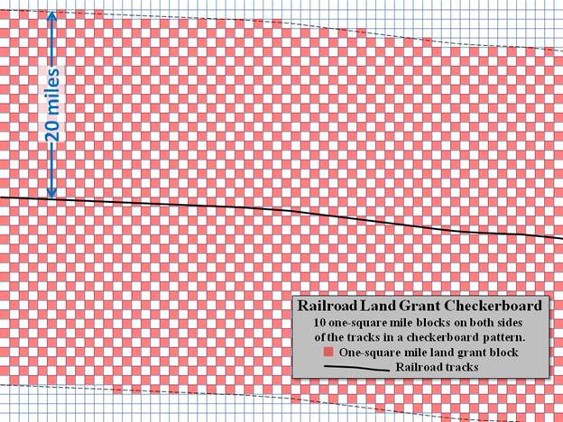
The link also notes:
In 1862 the Central Pacific and Union Pacific railroads were originally promised ten miles of checkerboard land on each side of the tracks, but to help meet expenses, ten was changed to twenty miles on each side in 1864. Because of the checkerboard pattern twenty miles would result in ten railroad blocks on each side of the tracks, and the federal government would keep most of the non-railroad blocks of land. The 1864 law also gave the railroad the mineral rights to their land as well. If a railroad failed to meet certain requirements such as a completion deadline these land grants could be forfeited.[3]
Note that 1 square mile = 640 acres.
Giving land to the railroads was more than just a give-away. It was necessary in order for there to be a railroad. Not just because of the business model but because of the water needs of locomotives which has already been discussed.
The Business Model
The railroads would build towns along their tracks at periodic intervals using a limited number of town plans so many towns looked alike. At least they gave each town its own name. They sold land to farmers and ranchers to grow crops and raise livestock (respectively). The farmers and ranchers had only the railroad to send their crops and livestock to market (outside the town) and they depended on the railroad to bring in manufactured goods. It was great to be the railroad. And the towns would attract businesses like general stores, hotels, restaurants, saloons/brothels, and banks. And a town government. I recommend this article from Invention & Technology Magazine: https://www.inventionandtech.com/content/same-town-different-name-1
An article that is a little less kind to railroad towns is here: http://www.let.rug.nl/usa/essays/1801-1900/the-iron-horse/railroad-towns.php
This didn’t work everywhere because not all land was suitable for farming and ranching. An example is much of the land in Utah and Nevada, especially the 40 Mile Desert which is still a desert and is still called the 40 Mile Desert. (Click Here}
Sometimes they would build just a refueling station and a town would grow up around it. From the above Wikipedia article https://en.wikipedia.org/wiki/Water_stop
Many water stops along new railways evolved into new settlements. When a train stopped for water and was positioned by a water tower, the boilerman swung out the spigot arm over the water tender and "jerked" the chain to begin watering. This gave rise to a 19th-century slang term "Jerkwater town" for towns too insignificant to have a regular train station.[6] Some water stops grew into established settlements: for example, the town of Coalinga, California, formerly, Coaling Station A, gets its name from the original coal stop at this location.[7] On the other hand, with the replacement of steam engines by diesel locomotives many of the then obsolete water stops, especially in deserted areas, became ghost towns.
The following is what happened to the Central Pacific Railroad.
From: https://en.wikipedia.org/wiki/Central_Pacific_Railroad
In 1885 the Central Pacific Railroad was leased by the Southern Pacific Company. Technically the CPRR remained a corporate entity until 1959, when it was formally merged into Southern Pacific. (It was reorganized in 1899 as the Central Pacific "Railway".) The original right-of-way is now controlled by the Union Pacific, which purchased Southern Pacific in 1996.
From: https://en.wikipedia.org/wiki/Catellus_Development_Corporation
In 1984, the Atchison, Topeka and Santa Fe Railway and the Southern Pacific Lines announced plans to merge all their assets into a single railway. As part of the merger, Santa Fe Pacific Realty, the real estate arm, was incorporated after the announcement. In 1986, the Interstate Commerce Commission denied the merger, as it would have created a monopoly on mainline freight movements in California and its bordering states.[2] As a result, the two railroads split in 1988. The real estate arm was spun off in 1989 and was renamed Catellus Development Corporation to manage the stations and land parcels next to the railroad tracks remaining under their ownership. It would later come to own numerous properties across the continent.
On June 7, 2005, Catellus Development Corporation announced it will merge into ProLogis (NYSE: PLD) for $3.6 billion ($5.5 billion in 2018 dollars).[3] The deal closed on September 15, 2005.
In late 2010, The private equity firm TPG Capital announced its intent to acquire a collection of real estate and the Catellus trademark from ProLogis.[4] The deal closed in 2011.
Today, the developer operates with headquarters in Oakland, California, with regional offices elsewhere.
In 1991 Catellus transferred a number of Washoe County parcels to the Atcheson, Topeka, and Santa Fe Railway. Washoe County Doc #1534872 recorded January 3, 1992. Click Here. This was after the ICC denied the merger. It must have been a complicated deal.
The value here is that it shows a large number of parcels. Even though they had been acquired in the 1860s they were only just now being sold.
These are the 23 parcels.
84-030-04 84-030-08 84-030-16 84-120-06 84-120-13 84-040-06
84-040-04 84-040-12 84-040-10 84-130-07 84-140-17 84-130-11
84-130-13 79-150-11 79-150-08 84-150-12 84-150-13 84-040-08
79-180-14 79-180-16 79-320-06 79-320-57 79-320-20
The deed contains the statement:
Grantor expressly covenants with Grantee that except as may be set forth on said Exhibit B:
(a) prior to the time of the execution of this deed, Grantor has not conveyed the fee simple estate, or any right, title or interest therein, to any person other than Grantee, and
(b) such estate is, at the tine of the execution of this deed, free from encumbrances done made of {sic} suffered by Grantor or any person claiming under Grantor.
Grantor makes no covenant or warranty herein, implied or otherwise, except as expressly set forth in the preceding sentence.
One of the items in Exhibit B is:
4. Rights of the public in and to any roads, highways or bodies of water that may cross or be located upon the Property.
It is probably just boilerplate for vacant land that was a land grant in the 1860s.
In Washoe County Doc #1935010 recorded October 19, 1995 the Atchison, Topeka, and Santa Fe Railway transferred a large number of parcels to Silver State Land Co. Click Here. The parcels were in Churchill, Lyon, Eureka, Humboldt, Lander, Storey, Pershing, Elko, and Washoe Counties.
Exhibit B lists the 45 parcels that are in Washoe County.
79-150-29 79-150-13 79-150-09 84-030-06 84-040-02 79-150-10
79-310-15 79-310-14 79-310-20 79-310-18 79-310-19 79-310-03
84-030-18 84-040-14 79-310-05 79-310-04 79-310-07 79-310-09
79-310-08 79-310-12 79-310-11 79-310-16 84-030-04 84-030-08
84-030-16 84-120-06 84-120-13 84-040-06 84-040-04 84-040-12
84-040-10 84-130-07 84-140-17 84-130-11 84-130-13 79-150-11
79-150-08 84-150-12 84-150-13 84-040-08 79-180-14 79-180-16
79-320-06 79-320-57 79-320-20
In Washoe County Doc #2117820 recorded July 17, 1997 we learn that some of the information in Exhibit B in the transfer to Silver State Land Co. had been left out and this new document is:
to provide description's of parcels listed in the above-mentioned Special Warranty Deed, specifically from which each corresponding Section, Township Range, Acreage, and Portion(s) thereof had been omitted.
Sec Forms A, herewith.
The parcel numbers are the same.
We also learn that Silver State Land Co. had become the Nevada Land and Resource Co. Click Here.
Sometime after these documents were recorded Washoe County added a leading digit to APN numbers so, for example, APN 79-150-11 became 079-150-11.
In 1997 Nevada Land and Resource Co. was acquired by Pico Holdings. From their Securities and Exchange Commission Form 10-K for the fiscal year ended December 31, 2007 www.annualreports.com/HostedData/AnnualReportArchive/p/NASDAQ_PICO_2007.pdf
Real Estate Operations
Our Real Estate Operations are primarily conducted through Nevada Land and Resource Company, LLC.
In April 1997, PICO paid $48.6 million to acquire Nevada Land, which at the time owned approximately 1,352,723 acres of deeded real estate in northern Nevada, and the water, mineral, and geothermal rights related to the property. Much of Nevada Land’s property is checker-boarded in square mile sections with publicly owned land. The properties generally parallel the Interstate 80 corridor and the Humboldt River, from Fernley, in western Nevada, to Elko County, in northeast Nevada.
Nevada Land is one of the largest private landowners in the state of Nevada. Real estate available for private development in Nevada is relatively scarce, as governmental agencies own approximately 87% of the land in Nevada. Before we acquired Nevada Land, the property had been under the ownership of a succession of railway companies, to whom it was a non-core asset. Accordingly, when we acquired Nevada Land, we believed that the commercial potential of the property had not been maximized.
Pico Holdings started selling off the properties. The value here is that it shows that even though these properties had been acquired in the 1860s most of them were only just now being sold. Evidently the properties were not suitable for farming, ranching, or anything else. Now it turns out that many of them are good for solar farms.
To be complete in telling the story, in 2021 Pico Holdings changed its name to Vidler Water Resources.
https://www.businesswire.com/news/home/20210308005324/en/PICO-Holdings-Inc.-Announces-Change-of-Name-to-Vidler-Water-Resources-Inc.-and-Results-for-the-Fourth-Quarter-Of-2020
In April 2022 Vidler Water Resources was acquired by D.R. Horton.
https://therealdeal.com/texas/2022/04/14/d-r-horton-scrambling-to-get-water-to-its-projects-buys-water-co-in-all-cash-deal/
The nation’s largest homebuilder is buying a water services company in an all-cash deal to ensure it has enough water for its communities.
D.R. Horton said Thursday that it bought Carson City, Nevada-based Vidler Water Resources. The total equity of the deal is valued at about $291 million, according to the announcement previously reported by the Dallas Morning News.
They wanted the water rights owned by Vidler.
The Central Pacific did not sit on all of its properties in the area. They sold at least one to a private individual, Thomas Fitch, in 1890. I talk about him in discussing his Deed. Click Here. (As I write this in June 2022 I own that property now.)
Part 5 - Olinghouse and Its Road
From the Nevada Historical Marker No. 24:
https://shpo.nv.gov/nevadas-historical-markers/historical-markers/olinghouse
Named for a former teamster-turned-sheepman, Elias Olinghouse, who settled in a quiet canyon at the base of the Pah Rah mountain range to get away from it all. As prospecting activities increased about him, Olinghouse was caught up in the whirl of things, buying several claims and erecting a small stamp mill in 1903 to process ores.
The district was first prospected in 1860; it was not organized, however, until 1899. Shortly thereafter, the region reached its peak of activity, producing $410,000 in gold and silver values between 1898 and 1903.
Both electric and telephone service were installed in 1903, and in 1907 the standard-gauge Nevada Railroad arrived. This short-lived railroad was completed from a junction on the Southern Pacific near Wadsworth to Olinghouse in February of 1907; regular operations ceased on November 1, 1907. Aside from its short life, the Nevada Railroad Company was distinguished by having the first Shay-geared locomotives to be used in Nevada.
Sporadic activity has continued at Olinghouse until the present time. Total production is estimated to have been $520,000.
This is an old marker and was last reported missing but it is a start.
This is a good Website for the history of Olinghouse and I will quote from it. https://forgottennevada.org/sites/olinghouse.html
Two men, Brooks McClane and F. Plane, originally located the source of the placer deposits on Green Hill in the year 1897. As the word spread, interest developed in the area, and people began to pour in. Some men pedalled their way on bicycles from Reno, 30 miles to the west; others came from Wadsworth, 8 miles to the east. Many mining claims were recorded, and a two-stamp mill was brought to the new settlement, and the left fork of the canyon creek, originally named McClanesburg, or Ora Post Office, and subsequently retitles [retitled] Olinghouse. Old W. Cattawalder "Bill" Williams was ever ready to claim fatherhood of the new town, for he was the one to locate Cabin No. 2, one of the main producers of the area, even though a later sale was made to a man named Dondero and a Reno restaurant keeper named Frankovitch. The pair of them in turn, sold it to the Springfield Nevada Mining Co.
-Railroads of Nevada and Eastern California- Volume 1: The Northern Roads - David F. Myrick - 1962
Olinghouse got its own Post Office hiring its Mary Norris as its first postmistress. 1898 July 16, Reno Evening Gazette
.....
More recent history of the Olinghouse area can be found on the Great Basin Minerals web site where it says, "With the advent of bulk-mineable heap leaching came renewed interest in the hard-rock potential of the district. Phelps Dodge was unable to find sufficient reserves in 1997, and so the property was picked up by Alta Gold Company, which quickly brought it into production. In 1999-2000, while Alta Gold was actively mining in the district, nearly all of the known fine crystallized wire and nest gold specimens were recovered and distributed. In April 2000, after about 30,000 ounces of gold production, Alta Gold went bankrupt, and, with only a few hours' notice, Olinghouse operations permanently shut down. This was primarily because of the low price of gold and spotty production. The properties reverted back to the bank that was holding Alta's operational loan. When the bank couldn't sell all the properties, they reverted back to the former owners, who are now engaged in long-term, multiple civil court battles to see who will control the choicest tracts. It is uncertain if another adventurous mining company will try to work Olinghouse once more and if any specimens will be preserved.
When it comes to mining you often see the terms “hard rock mining” and “placer mining”. From
https://www.nps.gov/yuch/learn/historyculture/placer-mining.htm
Unlike hardrock mining, which extracts veins of precious minerals from solid rock, placer mining is the practice of separating heavily eroded minerals like gold from sand or gravel. The word placer is thought to have come from Catalan and Spanish, meaning a shoal or sand bar. The word entered the American vocabulary during the 1848 California Gold Rush, and when gold was discovered in Alaska and the Canadian Klondike in the late 1890s, the gold-seekers who rushed northward brought with them various placer mining technologies. By far the simplest was the prospector’s pan that worked by swirling a combination of water and gravel or sand and allowing the lighter, rocky material to spill out. Relying on the fact that gold is heavier than sand and rock is the principle used in all placer mining operations.
Both hard rock mining and placer mining have taken place in Olinghouse. This has a good mining history of Olinghouse: https://ndep.nv.gov/uploads/documents/2015105fsFY21.pdf It is the Fact Sheet for the Olson Exploration Project, Nevada Department of Environmental Protection (NDEP). For a local copy Click Here.
Now let’s go back to, “Olinghouse got its own Post Office hiring its Mary Norris as its first postmistress. 1898 July 16, Reno Evening Gazette”
The U.S. Postal Service kindly found several documents for me.
The record of appointment of Mary Norris as the first postmaster of the Ora Post Office is on file at the National Archives and Records Administration. It’s been digitized is available online at https://catalog.archives.gov/id/78757514 (page 4) — I’m pasting below a copy of the record, for your reference.
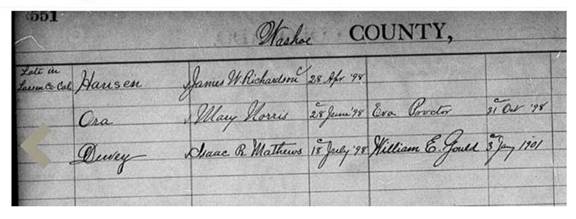
I have made a PDF of it. Click Here.
One of the names for the town was “Ora” and that is what they chose for the name of the Post Office. USPS further helped me with this:
The application to establish this Post Office is online at https://catalog.archives.gov/id/68526443
(see page 991).
I have made a local copy of it here as a PDF, Click Here.
It starts out:
Post Office Department
OFFICE OF THE FOURTH
ASSISTANT POSTMASTER GENERAL,
APPOINTMENT DIVISION,
WASHINGTON, D. C. May 8, 1898 189 .
Sir:
Before the Postmaster General decides upon the application for the establishment of a post office at County of Washoe State of Nevada it will be necessary for you to carefully answer the subjoined questions, get a neighboring postmaster to certify to the correctness of the answers, and return the location paper to the Department, addressed to me. If the site selected for the proposed office should not be on any mail route now under contract, only a "Special Office” can be established there, to be supplied with mail from some convenient point on the nearest mail route by a special carrier (see section 700. Postal Laws and Regulations of 1893), for which service a sum equal to two-thirds of the amount of the salary of the postmaster at such office will be paid by the Department.
You should inform the contractor, or person performing service for him, of this application, and require him to execute the inclosed certificate as to the practicability of supplying the proposed office with mail, and return the same to the Department.
Very respectfully,
Fourth Assistant PostMaster General
Apparently, if your town wanted its own Post Office all you had to do was apply for one and have someone volunteer to be the Postmaster/Postmistress. If you read the PDF you will see that they expected their post offices to be run by men.
Post Offices had to be connected to the outside world. Otherwise, how would they get the mail? So Post Offices were connected to the outside world by way of Post Roads.
Along with the application is a sketch of the road they proposed to use as the Post Road.
The phrase “Post Road” has a specific meaning.
The U.S. Constitution gives Congress the power “To establish Post Offices and post Roads” in Article I, section 8. So, what is a Post Road?
This is an interesting commentary on post roads written by Joseph Story in 1833.
https://press-pubs.uchicago.edu/founders/documents/a1_8_7s7.html
Who was Joseph Story? From https://en.wikipedia.org/wiki/Joseph_Story
Joseph Story (September 18, 1779 – September 10, 1845) was an associate justice of the Supreme Court of the United States, serving from 1812 to 1845. He is most remembered for his opinions in Martin v. Hunter's Lessee and United States v. The Amistad, and especially for his magisterial Commentaries on the Constitution of the United States, first published in 1833. Dominating the field in the 19th century, this work is a cornerstone of early American jurisprudence. It is the second comprehensive treatise on the provisions of the U.S. Constitution and remains a critical source of historical information about the forming of the American republic and the early struggles to define its law.
and
Story's opinion in Martin v. Hunter's Lessee (1816) was profoundly significant before Story ever so much as addressed the issue explicitly. The manner in which Story framed the American republic is profoundly indicative of his philosophy. Story noted, "The Constitution of the United States was ordained and established not by the States in their sovereign capacities, but emphatically, as the preamble of the Constitution declares, by 'the people of the United States.”
Now, what exactly is a post road?
From the Postal Laws of 1887: www.uspostalbulletins.com/pdf/PLandR_/1887/1864.pdf
(For a local copy Click Here.)
CHAPTER TWENTY-THREE.
OF POST ROADS; AND GENERAL PROVISIONS FOR ESTABLISHING MAIL CARRIAGE.
Sec. 727. What are Post Roads.—The following are established post roads:
All the waters of the United States, during the time the mail is carried thereon.
All railroads or parts of railroads which are now or hereafter may be in operation.
All canals, during the time the mail is carried thereon.
All plank roads, during the time the mail is carried thereon.
The road on which the mail is carried to supply any court house which may be without a mail, and the road on which the mail is carried under contract made by the Postmaster-General for extending the line of posts to supply mails to post-offices not on any established route, during the time such mail is carried thereon.
All letter-carrier routes established in any city or town for the collection and delivery of mail matters. (E. S., § 3984.)
That all public roads and highways while kept up and maintained as such are hereby declared to be post routes. (Act of March 1,1884, 23 Stats., 3.)
A post road is:
1. All public roads and highways (while they are maintained);
2. All railroads that are in operation;
3. All navigable waterways (rivers, canals, lakes).
That explains the information required by the application:
The name of the nearest office to the proposed one, on one side is Wadsworth. Its distance is ten__ miles in a East__ direction from the proposed office.
The name of the most prominent river near it is Truckee___
The proposed office will be ___five___ miles from said river, on the North
The name of the nearest railroad is S.P.___
Give the population to be supplied by the proposed office - Ans. _about 28_
A diagram, or sketch from a map, showing the position of the proposed new office, with neighboring river or creek, roads and other post offices, towns, or villages near it, will be useful, and is therefore desired.
A correct map of the locality might be furnished by the county surveyor, but this must be without expense to the Post Office Department.
The sketch was submitted with the application. It is Page 992 at https://catalog.archives.gov/id/68526443
For a local copy Click Here.
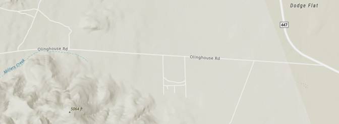
This is the sketch:
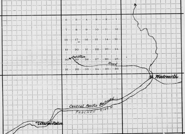
It does not appear to have been surveyed but it is close enough to see the road from Olinghouse to Wadsworth.
Bear in mind that SR 447 did not yet exist. Even SR 34 did not exist yet. The squiggly line coming up from Wadsworth is the Truckee River going to Pyramid Lake.
The old town of Olinghouse had more than just several mines and a post office. According to the Nevada Appeal https://www.nevadaappeal.com/news/2001/dec/19/the-backyard-traveler-historic-mining-camp-of-olin/:
A post office was opened in 1898 and a small business district developed over the next decade, which included the usual mining camp accoutrements, such as saloons, restaurants and lodging houses.
It also had a courthouse, a justice of the peace, and a constable. We know this because in 1913 the offices of justice of the peace and constable were abolished. See https://www.leg.state.nv.us/Statutes/26th1913/Stats191302.html#Stats191302page255
Chap. 171–An Act to abolish the office of justice of the peace and of constable for Olinghouse Township, Washoe County, Nevada, and to attach Olinghouse Township to Wadsworth Township for judicial purposes.
[Approved March 22, 1913]
The People of the State of Nevada, represented in Senate and Assembly, do enact as follows:
Section 1. The offices of justice of the peace and of constable of Olinghouse Township, Washoe County, State of Nevada, are hereby abolished and said township for such purposes, is hereby attached to Wadsworth Township in said county.
Sec. 2. The justice of the peace and the constable of said township shall turn over respectively, to the justice of the peace and to the constable of Wadsworth Township of said county, all books, records and files of their respective offices upon the passage of this act, and all proceedings pending in the justice’s court of said Olinghouse Township shall not be affected by the provisions hereof and the same shall be prosecuted to final determination in the justice’s court of said Wadsworth Township, and all writs and other processes in the hands of the constable of said Olinghouse Township shall be executed by the constable of said Wadsworth Township.
Sec. 3. All acts and parts of acts in conflict with this act are hereby repealed.
Sec. 4. This act shall take effect and be in force on and after the first day of April, 1913.
It would be unfair if the only way to go to the courthouse in Olinghouse (where you were being sued) was to use a toll road.
Would Olinghouse have been a viable town if the only way to reach it was by a toll road or a road which the Central Pacific could shut down anytime it wanted to?
NDOT has a map of Washoe County dated 2017 and revised 2021 at https://www.dot.nv.gov/travel-info/county-maps (Click on Washoe 1. The map is a PDF file 80.5 MBytes.)
The following is the map title:
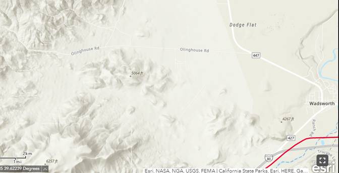
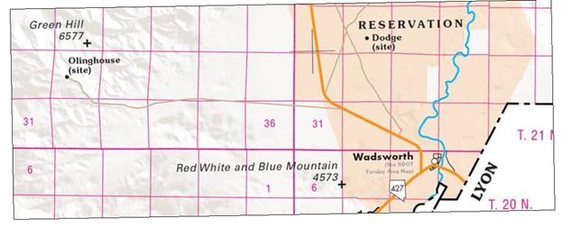
This shows the modern Olinghouse Road between Olinghouse and Wadsworth.
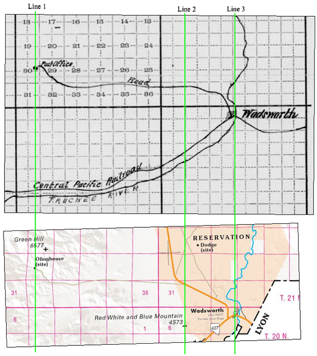
Now I am going to match it with the map of the Olinghouse post road.
I used my old TurboCad program to straighten the maps (which is why they are crooked) and added the three green lines to match things up.
Line 1 is the town of Olinghouse. Line 3 is Wadsworth. In the modern map the segment between Lines 2 and Line 3 is SR 447. In the old map SR 447 did not exist. Neither did SR 34. It is apparent that either they straightened that segment of Olinghouse Road or the 1898 sketch might not have been entirely accurate. It’s close enough for jazz. The squiggly line coming up from Wadsworth is the Truckee River going to Pyramid Lake.
Consider the following:
1. The town of Olinghouse came first, otherwise there would have been no need to put a post office there.
2. Olinghouse was not a self-contained self-supporting community. It was a mining town and had to be connected to the outside world. People, supplies, and equipment came into the town. The ore that was mined had to come out of the town to go to the outside world. Olinghouse was not on the Truckee River. In 1898 there was no railroad going to the town. There was only a road, Olinghouse Road.
3. Olinghouse Road was not likely to have ever been a paved road, and certainly not back then. Back then very few roads were even surfaced (gravel, sand-clay, or macadam).
When the Post Office Department said “That all public roads and highways while kept up and maintained as such are hereby declared to be post routes” that included graded and drained earth roads. That is because in 1898 most roads were earth (dirt) roads. Even in 1914 most public roads were dirt roads.
From: https://archive.org/download/publicroadmileag389unit/publicroadmileag389unit.pdf
UNITED STATES DEPARTMENT OF AGRICULTURE
BULLETIN No. 389
Contribution from the Office of Public Roads and Rural Engineering
LOGAN WALLER PAGE, Director
Washington, D. C. " T May 10, 1917
PUBLIC ROAD MILEAGE AND REVENUES IN THE CENTRAL, MOUNTAIN, AND PACIFIC STATES, 1914
A COMPILATION SHOWING MILEAGE OF IMPROVED AND UNIMPROVED ROADS; SOURCES AND AMOUNTS OF ROAD REVENUES; BONDS ISSUED AND OUTSTANDING; AND A DESCRIPTION OF THE SYSTEMS OF ROAD ADMINISTRATION, FISCAL MANAGEMENT, AND OTHER FACTORS AFFECTING ROAD IMPROVEMENT IN EACH STATE
Prepared jointly by the Division of Road Economics of the Office of Public Roads and Rural Engineering, and State Collaborators
On PDF page 36:
At the close of 1915 Nevada had 12,182 miles of public road, of which 262 miles, or 2.14 per cent, were surfaced. Of the surfaced roads 193 miles were gravel, 67 miles sand-clay, and 2 miles macadam. There were also reported 1,080 miles of graded and drained earth road. In 1909 Nevada reported 12,751 miles of public roads, of which only 46 miles, or 0.36 per cent, were surfaced, a gain in surfaced mileage the 6-year period of 216 miles. Detailed information regarding road mileage in 1914 is presented by counties in Table 20.
For a local copy Click Here.
While all public roads are post roads, not all post roads are public roads.
Was Olinghouse Road a public road when it became a post road?
I don’t see how Olinghouse could have been a viable town if the only way to reach it was by a toll road or a road which the Central Pacific could shut down anytime it wanted to.
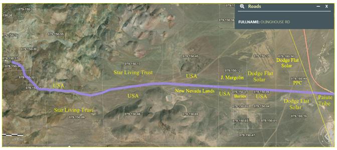
Olinghouse Road Today
This is what Olinghouse Road looks like today. I made it from the Washoe County GIS starting at
https://gis.washoecounty.us/wrms/?apn=079-150-12 .
I had to look up the owners and add them myself using my old TurboCad program. Note that Washoe County’s GIS Web site does not work with Firefox or Chrome in Vista-64. It requires Firefox or Chrome in at least Windows 7.
Note: PPC is Paiute Pipeline Co which has changed its name to Great Basin Gas Transmission Company and is owned by Southwest Gas. https://greatbasingtc.com/
I have made a PDF in landscape orientation. It is easier to see details in it. Click Here.
Parts of Olinghouse Road go through Federal land (USA), parts go through private land, and the part at the end that connects to SR 447 goes through the Pyramid Lake Paiute Tribe Reservation. Where it connects to SR 447, that segment of SR 447 is also on Reservation land.
You can see the remnants of the checkerboard pattern used in the land grants to the railroad. Some of the Federal land was apparently divided up at some point and became private land.
The parts that go through Federal land are public roads under NRS 405.191 by way of R.S. 2477.
https://www.leg.state.nv.us/nrs/NRS-405.html#NRS405Sec191
NRS 405.191 “Public road” defined; county roads and highways may be established on rights-of-way over certain public lands. As used in NRS 405.193 and 405.195, “public road” includes:
1. A United States highway, a state highway or a main, general or minor county road and any other way laid out or maintained by any governmental agency.
2. Any way which exists upon a right-of-way granted by Congress over public lands of the United States not reserved for public uses in chapter 262, section 8, 14 Statutes 253 (former 43 U.S.C. § 932, commonly referred to as R.S. 2477), and accepted by general public use and enjoyment before, on or after July 1, 1979. Except as otherwise provided in this subsection, each board of county commissioners may locate and determine the width of such rights-of-way and locate, open for public use and establish thereon county roads or highways, but public use alone has been and is sufficient to evidence an acceptance of the grant of a public user right-of-way pursuant to former 43 U.S.C. § 932. In a county in which a board of county highway commissioners has exclusive control of all matters relating to the construction, repairing and maintaining of public highways, roads and bridges within the county pursuant to NRS 403.090, the board of county highway commissioners may locate and determine the width of those rights-of-way and open those rights-of-way for public use for the purpose of designating county roads pursuant to NRS 403.170 or taking any other action concerning those rights-of-way pursuant to chapter 403 of NRS.
3. Any way which is shown upon any plat, subdivision, addition, parcel map or record of survey of any county, city, town or portion thereof duly recorded or filed in the office of the county recorder, and which is not specifically therein designated as a private road or a nonpublic road, and any way which is described in a duly recorded conveyance as a public road or is reserved thereby for public road purposes or which is described by words of similar import.
(Added to NRS by 1979, 1174; A 1981, 923; 1993, 1427; 1997, 1615; 2011, 300)
So, now we know that the parts of Olinghouse Road that go through Federal land are a public road under R.S. 2477. If the other parts were not also a public road then the parts on Federal land would be useless.
Fortunately, the other parts are a public road because under NRS 405.191:
NRS 405.191 “Public road” defined; county roads and highways may be established on rights-of-way over certain public lands. As used in NRS 405.193 and 405.195, “public road” includes:
1. A United States highway, a state highway or a main, general or minor county road and any other way laid out or maintained by any governmental agency.
See https://www.leg.state.nv.us/nrs/NRS-405.html#NRS405Sec191
Although Washoe County might not maintain Olinghouse Road now, they did in the non-so-distant past. See this map from the Washoe County Website at: https://www.washoecounty.gov/csd/files/CSD%20Images/renoroads_new
For a local copy Click Here.
It is called “Presumed Public Roads”.

It says: Original Date March 1999 / Revised October 2010
The following is the legend on the map.
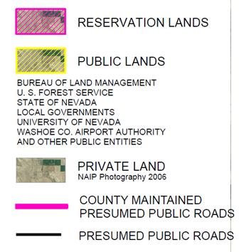
Olinghouse Road is solid black from Olinghouse to the border of the Pyramid Lake Paiute Tribe Reservation. It is also highlighted in pink from Olinghouse to SR 447 so Washoe County maintained it even if it is only a Presumed Public Road. Washoe County presumes it is all a public road.
Therefore, under NRS 405.191(1) it is a public road. Or at least it was a public road as of 2010.
NRS 405.191(1) starts with:
NRS 405.191 “Public road” defined; county roads and highways may be established on rights-of-way over certain public lands. As used in NRS 405.193 and 405.195, “public road” includes:
1. A United States highway, a state highway or a main, general or minor county road and any other way laid out or maintained by any governmental agency.
See https://www.leg.state.nv.us/nrs/NRS-405.html#NRS405Sec191
It mentions NRS 405.195 . NRS 405.195 is about petitions to change the status of roads:
NRS 405.195 Petition to open, reopen, close, relocate or abandon road; hearings and orders by board of county commissioners regarding petition; legal actions authorized.
.....
2. Upon conclusion of the public hearing, the board shall determine whether the road in question has acquired the status of a public road because:
.....
(c) The right-of-way was:
.....
(2) Accepted by use as access to a mining claim or other privately owned property.
.....
As already shown, Olinghouse Road has been used to access the mining claims in Olinghouse since the late 1890s.
But wait, there is a statement that accompanies the map dated 1999, that says:
These maps will neither create nor extinguish a public right-of-way by virtue of showing or not showing a road as a public road.
https://www.washoecounty.gov/csd/files/CSD%20Images/ppr_notice_1999
For a local copy Click Here.
It was not updated when the map was updated in 2010.
Does it matter? Once a public road always a public road unless the County Commissioners abandon it. I don’t see anything in the minutes of the Washoe County Commissioners meetings that they abandoned it.
On the map Washoe County says it maintains what it presumes to be a public road. It does not say it only presumes that it maintains a presumed public road.
If it did, then Washoe County would have a problem. It costs money to maintain a road, even a gravel road which Olinghouse Road was when I visited it in April 2015 and in May 2020. Would Washoe County have put all of the maintenance money in a big pot for the Roads Department to use as it sees fit without keeping records of how and where the money was spent? I hope not. If it did, it would merit an investigation by the Nevada Attorney General for likely misuse of public funds, maybe even corruption.
I think when Washoe County says (on the map) that they maintain Olinghouse Road I will take them at their word that they actually did just that and they have records (somewhere) to prove it. If not to me then to the Nevada Attorney General.
And then there is that thing where they only presume it is a public road and that:
These maps will neither create nor extinguish a public right-of-way by virtue of showing or not showing a road as a public road.
The 1999 statement also says:
At a hearing held April 27, 1999, the Washoe County Board of County Commissioners found the roads shown on these maps were presumed to be public roads based on NRS 405.191 and NRS 405.195.
I obtained the minutes of that meeting from Washoe County’s very new and very crappy page for searching and finding the minutes of the Washoe County Board of Commissioners meetings. For one thing you cannot directly link to specific documents. The process starts here (Good luck.):
https://login.imagesilo.com/PVE.aspx?txtEntityID=11032&txtUser=PUBLIC&txtPassword=Public1!&hRemote=0
Fortunately, I have downloaded the minutes. Click Here.
The discussion agenda item 99-389 MAPS DEPICTING ROADS PRESUMED TO BE PUBLIC - PUBLIC WORKS starts on PDF page 14. On PDF page 15:
Mr. Roundtree noted that adoption of these roads and making them a part of the public record starts the statute of limitations, which in this case is 15 years; and that if a determination to the contrary is not made during that 15-year period, all roads shown on these maps actually do become public and there is then no opportunity for someone to challenge them.
(Mr. Roundtree is listed as David Roundtree, Public Works Director.)
If we add 15 years from 1999 we get 2014. Therefore, according to the Washoe County Commissioners, in 2014 Olinghouse Road officially became a public road and there is now no opportunity for someone to challenge it.
What about the section of the road that is on the Pyramid Lake Paiute Tribe Reservation?
Indian Reservations are, in general, exempt from State law so Washoe County would not have the authority to make that section of the road a public road. Neither would the State of Nevada.
But what about SR 447 (State Route 447)? SR 447 is a public road.
There is a section of SR 447 that goes through the Reservation. From Google Maps:
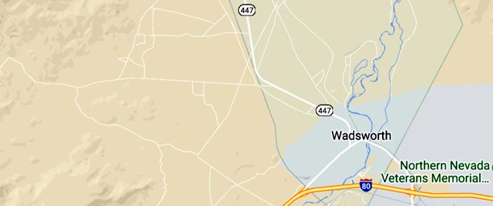
Indeed, most of SR 447 goes through the Reservation until it gets north of Pyramid Lake. (That is why they are called the Pyramid Lake Paiute Tribe.) There is also SR 446 and parts of SR 445 that are on the Reservation.
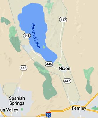
How did they get to be public roads?
At least one of the reasons they are public roads is because if Federal money is used to make or maintain a road on Reservation land then that road is a public road.
https://uscode.house.gov/view.xhtml?hl=false&edition=prelim&req=granuleid%3AUSC-2013-title23-section101&num=0
23 USC 101: Definitions and declaration of policy Text contains those laws in effect on June 1, 2022
From Title 23-HIGHWAYS CHAPTER 1-FEDERAL-AID HIGHWAYS
(22) Public authority.-The term "public authority" means a Federal, State, county, town, or township, Indian tribe, municipal or other local government or instrumentality with authority to finance, build, operate, or maintain toll or toll-free facilities.
(23) Public road.-The term "public road" means any road or street under the jurisdiction of and maintained by a public authority and open to public travel.
Was Federal money used to make or maintain the section of SR 447 on Reservation land?
Yes, the Nevada Department of Transportation gets Federal money from the Federal Highway Trust Fund.
See NDOT FUNDING PDF page 2: https://www.dot.nv.gov/home/showpublisheddocument/3149/636184509639130000
(For a local copy Click Here.)
This was not a one-off. From the State of Nevada Department of Transportation 2019-2021 Biennial Budget, Budget Subcommittee Presentation, PDF page 15 shows the amounts that NDOT received from the Federal Aid Highway Program from 2004 - 2018. https://www.leg.state.nv.us/App/InterimCommittee/REL/Document/13773
For a local copy Click Here.
So that section of SR 447 is a public road.
Does Washoe County get Federal money for its roads?
Yes, they get Federal money through NDOT. From the above reference (Click Here) PDF page 9, for the Fiscal Year 2013 Washoe County received $11,505,477 from NDOT.
There is also the matter that Counties are creatures of the State just as Cities are creatures of the County. They are not independent entities. Counties must operate according to the Nevada Revised Statutes (NRS) and Cities must operate according to County laws as well as the NRS.
Therefore, since NDOT gets Federal money, and since Washoe County gets money from NDOT, under 23 USC 101 all of Olinghouse Road from the old town of Olinghouse to SR 447 is a public road.
Let’s go back to:
23 USC 101: Definitions and declaration of policy Text contains those laws in effect on June 1, 2022
From Title 23-HIGHWAYS CHAPTER 1-FEDERAL-AID HIGHWAYS
(22) Public authority.-The term "public authority" means a Federal, State, county, town, or township, Indian tribe, municipal or other local government or instrumentality with authority to finance, build, operate, or maintain toll or toll-free facilities.
(23) Public road.-The term "public road" means any road or street under the jurisdiction of and maintained by a public authority and open to public travel.
1. Washoe County is a “public authority”;
2. Washoe County, by its own documents, maintained Olinghouse Road all the way from the town of Olinghouse to SR 447;
3. Olinghouse Road, all the way from the town of Olinghouse to SR 447, has been open to public travel since at least 1898 when the town of Olinghouse got a U.S. Post Office with Mary Norris as the first postmistress and Olinghouse Road was a Post Road. This was before there even was a SR 447 or its predecessor SR 34. This was when Olinghouse Road went from Olinghouse to Wadsworth. Sections of Olinghouse Road later became parts of SR 34 and later SR 447.
Therefore, under 23 USC 101 all of Olinghouse Road from the old town of Olinghouse to SR 447 is a public road.
Plus, there are all of the references to Olinghouse Road being a County Road. See Part 7 - More Evidence.
Washoe County’s Map of Presumed Public Roads may have been produced in response to NRS 403.190 which is available at https://www.leg.state.nv.us/nrs/NRS-403.html#NRS403Sec190
I will reproduce it here.
NRS 403.190 Map of county roads filed by board of county highway commissioners; effect of filing of map that includes an R.S. 2477 road; authority of user to file map of minor county road; fees.
1. Except as otherwise provided in subsection 4, upon laying out and designating the county roads as required in NRS 403.170, the board of county highway commissioners shall cause a map of the county to be made, showing the county roads and their designations. The board shall file one copy of the map with the clerk of the board of county highway commissioners, one copy with the Department of Transportation, one copy with the county clerk and one copy with the county recorder.
2. If the map required pursuant to subsection 1 includes a county road located on a right-of-way that the board of county highway commissioners has located, determined the width of and opened for public use pursuant to subsection 2 of NRS 405.191:
(a) The filing of copies of the map pursuant to subsection 1 constitutes the establishment of the existence and location of a right-of-way that is open for public use; and
(b) Acceptance of the map by the Department of Transportation constitutes acknowledgment by the Department of the establishment of the existence and location of a right-of-way that is open for public use.
3. When any road has been designated by the board of county highway commissioners as a standard county road, as provided in NRS 403.180, that designation must be made on the copies of the map on file with the clerk of the board of county highway commissioners, the county clerk, the Department of Transportation and the county recorder.
4. The board of county highway commissioners need not include a minor county road upon the map required by subsection 1. Any person who uses a minor county road may file with the county recorder a map showing the location of the road, appropriately emphasized in black ink upon the map by the person filing it. The map must:
(a) Be a topographical map prepared by the United States Geological Survey, unless the board of county highway commissioners determines that other specific maps are acceptable.
(b) Have written on its face, in black ink, the townships, ranges and sections through which the road traverses.
> The map so filed is evidence of the existence and location of the road. Each person filing such a map shall pay to the county recorder a fee of $17 for the first sheet of the map plus $10 for each additional sheet.
[3: Art. 4:257:1913; 1919 RL p. 2903; NCL § 5377] — (NRS A 1979, 1174; 1993, 1400; 2001, 3220; 2011, 299)
If this is why Washoe County produced the map I see some problems here.
1. The requirement that counties make a map of the county roads and their designations and file one copy with the clerk of the board of county highway commissioners, the county clerk, the Department of Transportation and the county recorder goes back to 1979. https://www.leg.state.nv.us/Statutes/60th/Stats197906.html#Stats197906page1174
The requirement predates this map. They cannot say the law was made after they made the map.
2. At the April 27, 1999, meeting of the Washoe County Board of County Commissioners this is what the Commissioners decided concerning the “Presumed Public Roads” map:
On motion by Commissioner Bond, seconded by Commissioner Shaw, which motion duly carried, Chairman Galloway ordered that the maps depicting roads within Washoe County which are presumed to be public roads be adopted; and that staff be directed to utilize the information contained in the maps as it relates to public roads and public access issues in the review of development proposals. It was further ordered that the maps be recorded in the Recorder's Office if it is determined that it is legally allowable to do so.
a. “that staff be directed to utilize the information contained in the maps as it relates to public roads and public access issues in the review of development proposals” even though “These maps will neither create nor extinguish a public right-of-way by virtue of showing or not showing a road as a public road.”
Washoe County staff could tell a Developer that the residents of his proposed Development would be able to access their homes via a public road and then, later, say no, it is not a public road after all and your residents cannot use it.
b. “It was further ordered that the maps be recorded in the Recorder's Office if it is determined that it is legally allowable to do so.”
I don’t see that Washoe County recorded it with the Washoe County Recorder. How could it not be legally allowable to record this map? Or, maybe they just forgot.
c. The Nevada Department of Transportation says they do not have a copy of the Map. For my correspondence with them Click Here.
3. NRS 403.190 is an affirmative duty, a commandment. It does not say that counties can use weasel words like presume and say:
These maps will neither create nor extinguish a public right-of-way by virtue of showing or not showing a road as a public road
4. I don’t see anything about a 15 year period after which the presumed public road become actual public roads.
5. The map is supposed to be a public document but the map says:” Reproduction is not permitted without prior written permission from the Washoe County Public Works Department.”
I don’t think that would pass muster with Nevada’s NRS CHAPTER 239 - PUBLIC RECORDS starting at https://www.leg.state.nv.us/nrs/nrs-239.html#NRS239Sec001
In November 2021 I asked Washoe County if Olinghouse Road was still a Washoe County Road. They gave me a non-answer:
Thank you for contacting Washoe311. Olinghouse Rd is not a road maintained by Washoe County. The road runs through various private properties in addition to some sections passing through land that belongs to the U.S. Bureau of Land Management.
Click Here.
That is when I started doing the research and writing this article. (If it were printed out it would be 85 pages, so this is now a book.)
In March 2022 I sent Washoe County an email which started by stating more directly:
There is good evidence that Olinghouse Road was (and still is) a Washoe County public road even if Washoe County has stopped maintaining it.
Then I presented some of the evidence I had found. It was the BLM document Draft Environmental Impact Statement for the proposed Olinghouse Mine Project dated September 12, 1997 (Click Here) and the Nevada State Highway Department Planning Survey Division “General Highway Map for Washoe County” in 1965. (Click Here)
Washoe County responded with another non-answer but with a twist:
Unfortunately, Olinghouse Road is not maintained by Washoe County. This road is located on private property and there is no recorded map that shows Washoe County had maintained or does maintain this. The draft BLM document would have to reference a recorded map for this to show that Washoe County did maintain Olinghouse Road. Hopefully this helps clarify your question.
Click Here.
It was sent to me by Mr. Alex Mayorga, Professional Engineer, Engineering & Capital Projects Division, Community Services Department. The Community Services Department is in charge of the roads: https://www.washoecounty.gov/csd/operations/roads/index.php
Notice that Mr. Mayorga said, “ there is no recorded map that shows Washoe County had maintained or does maintain this.”
It looks to me that Mr. Mayorga knew about the “Presumed Public Roads” map and he knew that it hadn’t been recorded. But remember, the reason it was not recorded was due to Washoe County’s failure to comply with NRS 403.190 .
It also looks to me that Washoe County is colluding with NextEra Energy in an attempt to make people believe that Olinghouse Road is not a public road.
As a result there was no point in continuing the conversation with Washoe County.
And Shame on Washoe County.
Part 6 - More Maps - The first is by the U.S. Geological Survey dated 1915, the second is the General Highway Map, Washoe County Nevada, Prepared by the Nevada State Highway Department, 1947.
This map is by the United States Geological Survey dated 1915. It shows the road from Olinghouse to Wadsworth. https://www.nps.gov/parkhistory/online_books/geology/publications/bul/612/images/sheet22.jpg
I have made a PDF of it. Click Here.
Zooming in shows:
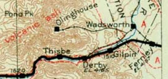
Further south it shows Virginia City.
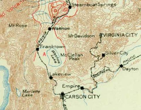
Notice that it shows only one road to Virginia City.
In 1915 there was another road. It was a toll road (Old Geiger Grade) constructed in 1862 that went between Virginia City and Reno/the Truckee Meadows. This is the historical marker on the new Geiger Grade constructed in 1936 (which is a public road, not a toll road).
Did USGS leave it off their map in 1915 because it was a toll road and they only showed public roads?
Or did they not want to pay the toll to use the road so they could map it?
They didn’t have that problem with the road from Olinghouse to Wadsworth.
The following is from the General Highway Map, Washoe County Nevada, Prepared by the Nevada State Highway Department, 1947. It is from https://www.dot.nv.gov/travel-info/maps/historical-maps/historical-county-maps#Washoe Select Zone 1 1948. For a local copy Click Here.
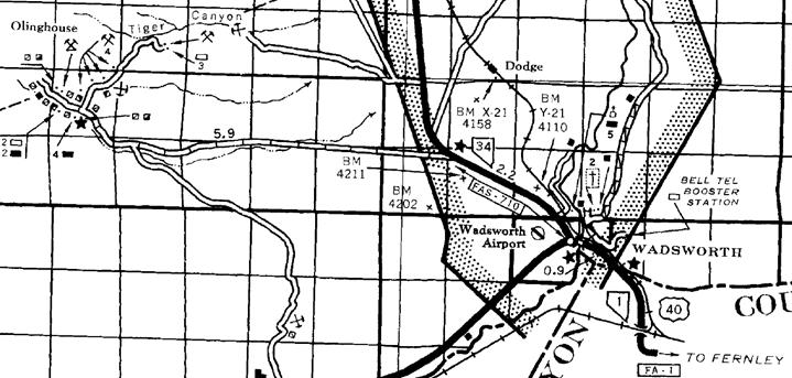
It shows the road from Olinghouse to SR 34 to Wadsworth. That section of SR 34 later became the present section of SR 447.
The legend says Olinghouse Road is a graded and drained road.
It is better than an unimproved road
and much better than a primitive road.
Note that there was an unimproved road going south from just east of Olinghouse. This is the symbol for a mine:
so there must have been a mine down there. I wonder what happened to it and the road to it.
Notice U.S. 40 going through Wadsworth. And where is I-80?
The answer is that in 1948 there was no I-80. The Interstate Highway System did not start being built until the Federal Aid Highway Act of 1956 was passed. https://en.wikipedia.org/wiki/Interstate_Highway_System
Technically the Interstate Highway System is called the Dwight D. Eisenhower National System of Interstate and Defense Highways. That is because the Federal Aid Highway Act of 1956 was passed when Dwight D. Eisenhower was President of the United States (January 20, 1953 – January 20, 1961).
In fact it was his idea. Eisenhower had been the Supreme Allied Commander Europe during the Second World War. He saw how useful the German Autobahn (built by Hitler) had been to the Nazis. We didn’t have such a useful interstate highway system. Now we do. That is why it is the Dwight D. Eisenhower National System of Interstate and Defense Highways.
When it came into our area they bypassed Wadsworth. :-(
But at least they put in an exit. In fact they put in two exits, apparently using the remnant of U.S. 40.
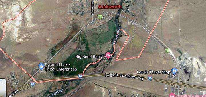
The Central Pacific sold at least one of their land grant properties in the area in the decades after they acquired it but held onto most of it for more than 100 years.
There is no evidence that they ever made Olinghouse Road a toll road or restricted public access to it.
It is reasonable to believe that:
1. Most of the people going to the town of Olinghouse used the railroad to go to Wadsworth first. Most of the people coming from the town of Olinghouse went to Wadsworth and then took a train to somewhere.
2. Most (maybe all) of the processed ore from the mines in Olinghouse went to Wadsworth and was then shipped out on the railroad. Until it ran out there was enough of it for the Nevada Railroad Company to put in a railroad between Olinghouse and Wadsworth.
3. If the Central Pacific had made their segments of Olinghouse Road a toll road they would have had to hire and pay toll takers. The cost of the toll takers would have been greater than the amount of tolls collected.
4. If the Central Pacific had made their segments of Olinghouse Road a toll road or had gated them it would have strangled the town of Olinghouse. This would have reduced the railroad revenue the Central Pacific was making from the town of Olinghouse, and the railroad was the Central Pacific’s core business.
Therefore, the Central Pacific had nothing to lose and everything to gain by allowing the public unrestricted use of the segments of Olinghouse Road going through the Central Pacific’s properties. If only by use and custom Olinghouse Road would be a public road all the way from Olinghouse to SR 447/SR 34/Wadsworth.
That might be why, in 1991 when Catellus transferred a number of Washoe County parcels to the Atcheson, Topeka, and Santa Fe Railway, Exhibit B contains the following exclusion:
4. Rights of the public in and to any roads, highways or bodies of water that may cross or be located upon the Property.
Part 7 - More Evidence
A. The Bureau of Land Management issued a Draft Environmental Impact Statement for the proposed Olinghouse Mine Project dated September 12, 1997.
In it they referred to “Olinghouse County Road” many times.
The full report is at: https://commons.wikimedia.org/wiki/File:Draft_environmental_impact_statement_-_Olinghouse_Mine_Project_(IA_draftenvironmental00unit).pdf
For a local copy (43.8 MBytes) Click Here. I have culled out the pages that contain the references to “Olinghouse County Road” . (3.9 MBytes) Click Here. It is text searchable using Adobe Acrobat Reader and probably many other PDF readers. Search for Olinghouse County Road.
I have made an html page that contains all of them. Click Here.
These are two of them. The references to the PDF page number is the PDF page number in the full report.
3. Report page 1-4, PDF page 29:
Access to the site would be from State Route 447 to the Olinghouse County Road.
4. Report page 2-13, PDF page 41:
2.1.3.1 Haul Roads
A 70-ft wide haul road, approximately 3.0 miles in length, would be constructed to connect the mine pits, waste rock dump, and ore processing facilities. The haul road would cross Olinghouse County Road near the historic town of Olinghouse, and Alta would coordinate with Washoe County to implement adequate traffic controls at this crossing.
....
2.1.3.2 Access Roads
Access to the mine would be from State Route 447 to the Olinghouse County Road, which would be improved by the addition of a gravel surface from the intersection of State Route 447 to the proposed haul road; however, the road would not be widened. Alta would negotiate with the Pyramid Lake Paiute Tribe for access across Reservation lands.
It says that they would negotiate with the Pyramid Lake Paiute Tribe for access across Reservation lands. Presumably they mean the short section where Olinghouse Road meets SR 447.
There are no documents recorded on the Washoe County Recorder’s Web site showing this was done.
It is reasonable to believe the reason is because Alta determined that they didn’t need to, that the short section where Olinghouse Road meets SR 447 was a public road. That doesn’t mean Washoe County owned it, only that it was a public road like the segment of SR 447 that goes through the Reservation.
B. In 2011 the Pacific Gold Corp stated in its Form 10-K filing with the Securities and Exchange Commission for the year ended December 31, 2011 that:
1. It owned Fernley Gold, Inc
2. Fernley Gold, Inc. entered into a lease agreement in 2004 for the right to mine the property and claims known as Butcher Boy and Teddy.
3. The property is accessible from the junction of paved State Route 34 (447) approximately 1.5 miles north-west of the town of Wadsworth, Nevada, onto a county-maintained gravel road which runs several miles west into the Olinghouse Canyon. The mine access road begins at the midpoint of the Olinghouse road heading north approximately two miles to the site.
UNITED STATES SECURITIES AND EXCHANGE COMMISSION
WASHINGTON, DC 20549
FORM 10-K
ANNUAL REPORT PERSUANT TO SECTION 13 OR 15(d) OF THE SECURITIES EXCHANGE ACT OF 1934 FOR THE FISCAL YEAR ENDED DECEMBER 31, 2011
COMMISSION FILE NUMBER 000-32629
PACIFIC GOLD CORP.
BUSINESS
Pacific Gold is engaged in the identification, acquisition, and development of mining prospects believed to have known gold and/or tungsten mineral deposits. The main objective is to identify and develop commercially viable mineral deposits on prospects over which the company has rights that could produce revenues. These types of prospects may also contain mineral deposits of metals often found with gold and/or tungsten which also may be worth processing. Development of commercially viable mineral deposits of any metal includes a high degree of risk which careful evaluation, experience and factual knowledge may not eliminate, and therefore, we may never produce any significant revenues.
Pacific Gold Corp. owns 100% of four operating subsidiaries: Nevada Rae Gold, Inc., Fernley Gold, Inc., Pilot Mountain Resources Inc., and Pacific Metals Corp., through which it holds various prospects in Nevada and Colorado. The Company intends to acquire through staking, purchasing and/or leasing arrangements additional prospects, from time to time, in which there may be gold, tungsten and/or other mineral deposit potential.
......
Fernley Gold, Inc.
Fernley Gold, Inc. entered into a lease agreement in 2004 for the right to mine the property and claims known as Butcher Boy and Teddy.
The property and claims are located 34 miles east of Reno, Nevada, just off highway I-80. The area known for placer gold mineral deposits, and commonly referred to as the Olinghouse Placers, has a rich mining history. The lease includes two water wells and water rights. The Company is required to make monthly lease payments to the property owner and annual BLM fees in order to keep the project in good standing.
Location
The property is accessible from the junction of paved State Route 34 (447) approximately 1.5 miles north-west of the town of Wadsworth, Nevada, onto a county-maintained gravel road which runs several miles west into the Olinghouse Canyon. The mine access road begins at the midpoint of the Olinghouse road heading north approximately two miles to the site.
{Emphasis added}
This 2011 filing by Pacific Gold is available at:
https://www.sec.gov/Archives/edgar/data/1137855/000151597112000090/f10k123111.htm
I have made a text-searchable PDF of it. Click Here.
Part 8 - The Loxodonta africana in the Room
This comes to us by way of Washoe County Doc #5225531 recorded 9/13/2021. For a local copy Click Here.
NextEra Energy/Dodge Flat Solar has bought an easement from the Pyramid Lake Paiute Tribe.
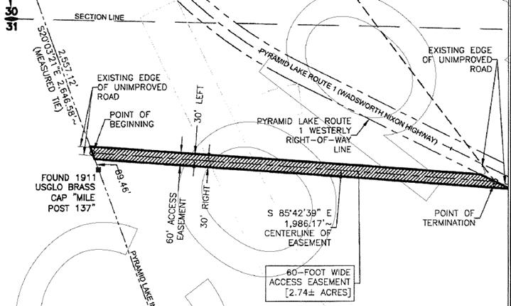
The resolution isn’t great at the bottom containing this statement, but it is good enough to show that this map was made in 2018.
I think this is the first map I have seen that is intentionally deceptive. It has an agenda.
Why do I think that?
1. Look at the road labeled “Pyramid Lake Route 1 (Wadsworth/Nixon Highway).
The official name of this road is SR 447. That is the name everyone knows it by.
2. The land they are buying an easement on (a 60-Foot Wide Access Easement) does not have a name. It doesn’t go anywhere. It is just a stub connected to some road on the Pyramid Lake Paiute Tribe Reservation.
Nope. That is where Olinghouse Road connects to SR 447.
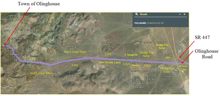
3. It says the west and east edges are an “Existing Edge of Unimproved Road.” They are saying that the road they are buying an easement on is an unimproved road.
No, that is an outright lie.
In 2018 Olinghouse Road was a maintained gravel road. That means it is an improved road. (Even a dirt road can be an improved road if it is maintained. I know because I live on a dirt/gravel road.) Washoe County maintained Olinghouse Road for years. Go back to the map that Washoe County made. Click Here.
The following is a document submitted to Washoe County by Dodge Flat Solar as part of their application package.
For a local copy Click Here
MEMORANDUM
To: Trevor Lloyd, Washoe County Planning and Development
From: David Hochart, Dudek, on behalf of Dodge Flat Solar, LLC
Subject: Special Use Permit (SUP) Application Package for the Dodge Flat Solar Energy Center
Date: October 16, 2017
cc: Eric Koster, Dodge Flat Solar LLC
Jesse Marshall, Dodge Flat Solar LLC
PDF page 79:
1.4 Impacted Washoe County Roads
The proposed project site will be accessed exclusively from Olinghouse Road (see Figure 2). Per the Washoe County Road Map, Revised October 2010, Olinghouse road is classified as a County Maintained Presumed Public Road. Construction traffic will utilize Olinghouse Road from SR-447, westerly 0.67 miles to the easterly project boundary, and then continuing 0.37 miles through the project, allowing for access to the internal private project road system, for a total of approximately 1.04 miles of road usage and impacts during construction.
In the vicinity of the project, Olinghouse Road is currently an approximately 25’ wide dirt road running east to west. It is generally in good condition, with no major erosion or deterioration issues (See Figure 3).
{Emphasis added}
They lied again. Olinghouse Road was a gravel road, not a dirt road.
They even show it on PDF page 73 (in the Memorandum).
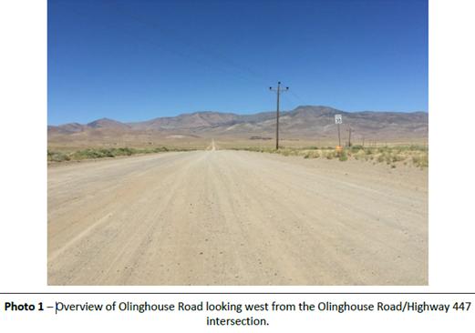
That is a gravel road.
They admit it on PDF page 21:
9. Could neighboring properties also be served by the proposed access/grading requested (i.e. if you
are creating a driveway, would it be used for access to additional neighboring properties)?
|
Access to the project site is readily available from Olinghouse Road that consists of an improved gravel road that is being maintained. No new access driveways are proposed that would result in new access to additional neighboring properties. Should the Wadsworth Bypass be approved by Nevada Department of Transportation and constructed prior to the Dodge Flat Energy Center, the Bypass would serve as the primary route of access, connecting to Olinghouse Road.
|
{Emphasis added}
PDF page 80:
1.5 Rehabilitation, Maintenance and Restoration
At the beginning of construction, Olinghouse Road would be rehabilitated as needed to support the anticipated additional construction traffic loadings, which may include stabilization and improvement of the existing road base, adding compacting gravel as appropriate and as approved by the Washoe County Engineer. During construction, additional gravel may be applied and compacted as needed to maintain suitability for construction traffic, to support local residential traffic in the area, and to assure unimpeded emergency vehicle access. After construction, Olinghouse Road would be rehabilitated as needed, to restore the existing design life, as approved by the Washoe County Engineer.
{Emphasis added}
Why would Washoe County stop maintaining a road that has residential traffic on it? Olinghouse Road is also needed to get to the mining operations at Olinghouse.
On June 27, 2022 I took a trip out to Olinghouse Road.
This is the view from SR 447 looking west where Olinghouse Road connects to it. (That dark blue object is my Subaru.)
This is the Stop sign
on Olinghouse Road when you are leaving Olinghouse Road and going onto SR 447. 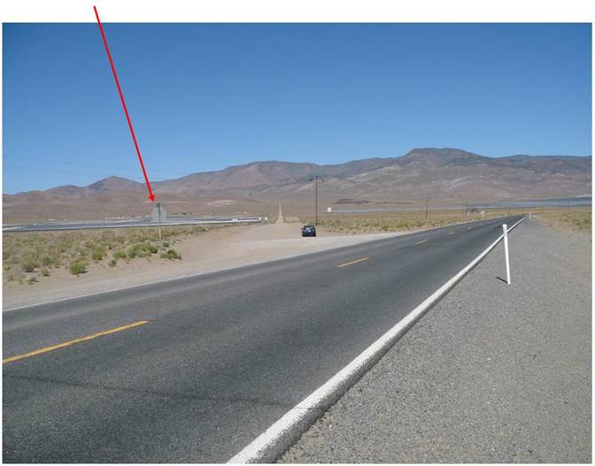
The Stop sign also holds the road sign identifying Olinghouse Road.
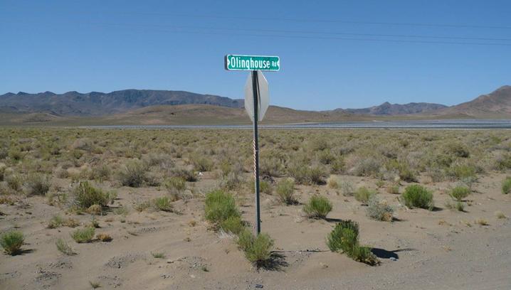
This is my Subaru sitting on Olinghouse Road in front of the Speed Limit sign (35).
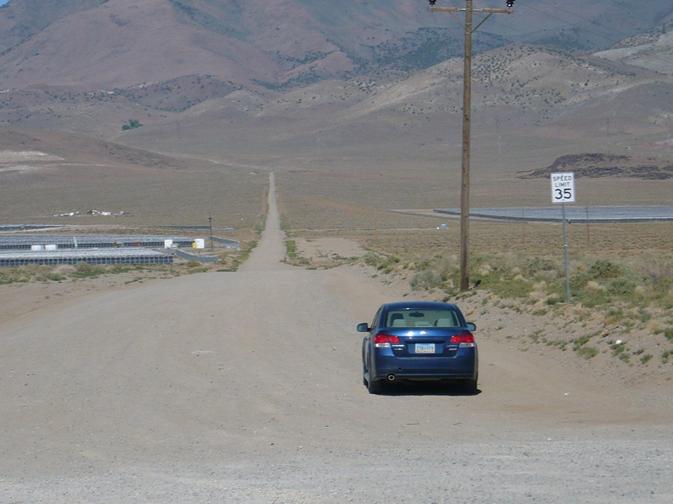
To the left you can see some of the Dodge Flat Solar farm solar arrays. There are more on the right further away.
This is the Dodge Flat Solar array on the left side of the road using a zoom lens.
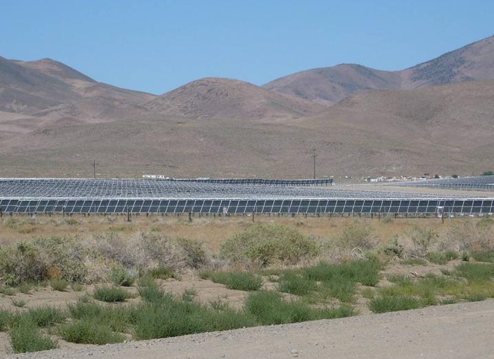
Things to note:
1. There is no gate barring entry onto the road.
2. There are no signs saying something like “No Trespassing” or “Restricted Entry.”
There is nothing to distinguish Olinghouse Road from any other public road.
Let’s go back to the easement they recorded. Why would they record that deceptive map? What is their agenda?
Were they just trying to keep their easement under the radar so as to not attract attention?
Why did they buy an easement on what was already a public road?
The kindest explanation is that Olinghouse Road is nominally 25’ wide and they wanted to widen it to 60’ wide. Since they would be widening it onto Reservation land, that is why they needed an easement.
Or, they want people to think that Olinghouse Road is not a public road. They have already put in the Dodge Flat Solar farm and they want to do more. If the owners of the other properties can be convinced that their properties are not accessible by a public road then their properties are basically worthless. Then NextEra Energy can buy them cheap.
I own APN 079-150-12. I won’t be selling it cheap, maybe not at all.
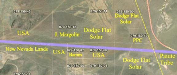
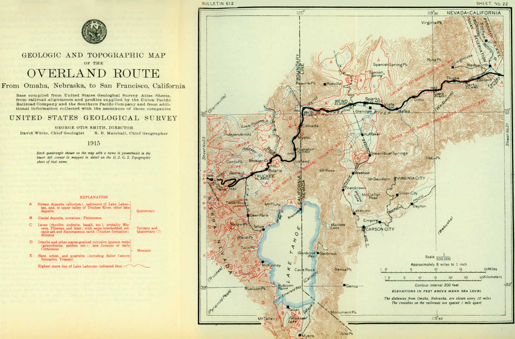
I am thinking of putting up a double-wide with a large outbuilding for my vehicles and for storage and living there. I could use the rest of the 160 acres to raise buffalo. It takes a tough man to raise a tender buffalo.
BTW, Loxodonta africana is the African bush elephant. See:
https://en.wikipedia.org/wiki/African_bush_elephant
and
https://www.worldwildlife.org/stories/what-s-the-difference-between-asian-and-african-elephants-and-10-other-elephant-facts
Their main stomping grounds are the savannas. They are not well adapted to the desert.
If they were, Virginia City would have the Annual Elephant Races instead of the Annual Camel Races.
https://travelnevada.com/event/international-camel-ostrich-races/
(A camel is a horse designed by a committee. An elephant is a horse designed to Mil Spec.)
Part 9 - Fast and Loose with Easements
The above is not the only time NextEra Energy has played fast and loose with easements.
There is their Amendment of Conditions Application Package for the Dodge Flat Solar Project dated October 9, 2020.
WAC20-0002_ap-3.pdf is available at: https://www.washoecounty.gov/csd/planning_and_development/applications/files-planning-development/comm_dist_four/2020/Files/WAC20-0002_ap.pdf
For a local copy Click Here.
They say that SR 447 to Olinghouse Road is not the only way to get to their project. There is also the Southern Access Utility Road.
In the following the emphases are mine.
PDF Page 17:
The two access road/utility crossings on BLM lands and two segments of the Southern Access Utility Road that cross BLM lands were the subject of the Dodge Flat Utility and Road Crossing Project Environmental Assessment processed by the BLM Sierra Front Field Office (DOI-BLM-NV-C020-2019-0017-EA). The BLM concluded that impacts associated with the proposed road/utility crossings and use of the existing access road on public lands would not be significant and signed a Finding of No Significant Impact on August 29, 2019.
PDF Page 18:
Locally, the proposed project would be accessed via two potential access routes (1) SR-447 and Olinghouse Road, via access road easements issued by the Pyramid Lake Paiute Tribe to the site and (2) Southern Access Utility Road. Access route (1) is included in the current SUP. The Southern Access Utility Road (2) would be accessed via Interstate 80 (I-80) to Canon Road. The Southern Access Utility Road crosses private lands and two segments of public lands managed by the BLM. The two segments that cross BLM lands are included in the ROW request that was the subject of the Environmental Assessment processed and approved by BLM’s Sierra Front Field Office. The existing road is currently used to access nearby mining operations, a natural gas line and associated facilities, and private lands. The existing dirt road is approximately 20 feet wide and the segments on BLM-managed lands are a total length of 0.5 mile (1.2 acres).
PDF Page 23:
Ancillary Facilities
Access Road
......
While DFS expects to utilize Olinghouse as the primary access, an auxiliary access route (Southern Access Utility Road) has been identified to support site access in the event the agreement is terminated. Additionally, this route may be used to alleviate construction traffic through Wadsworth.
The proposed Southern Access Utility Road (auxiliary access road) crosses private lands and two segments of public lands managed by the BLM. The two segments that cross BLM lands are included in the ROW request that was the subject of the Environmental Assessment processed and approved by BLM’s Sierra Front Field Office. The existing road is currently used to access nearby mining operations, a natural gas line and associated facilities, and private lands. The existing dirt road is approximately 20 feet wide and the segments on BLM-managed lands are a total length of 0.5 mile (1.2 acres). DFS is pursuing land use agreements with the private land owners for use of the remaining segments of the road that are on private lands. Because the road already exists, no construction activities for the Southern Access Utility Road would be required outside the roads’ existing footprints.
So where is this route?
They don’t show it.
They refer to Dodge Flat Utility and Road Crossing Project Environmental Assessment processed by the BLM Sierra Front Field Office (DOI-BLM-NV-C020-2019-0017-EA).
They did not attach the BLM report or provide a link to where it can be found.
I found it at: https://eplanning.blm.gov/public_projects/nepa/124372/20002495/250002966/Dodge_Flat_Decision_Record.pdf
For a local copy Click Here.
They have a map.
This is Figure 1-2. I have added the labels with the red lines to point out some things.
The Southern Access Utility Road starts at Olinghouse Road on a property that Dodge Flat Solar owns (079-180-16, Black), goes through a short piece of BLM land (Red), then goes through private land on 084-040-06 (Green). Then it goes through another short section of BLM land (Red) and then more private land (Green) and then indirectly to I-80.
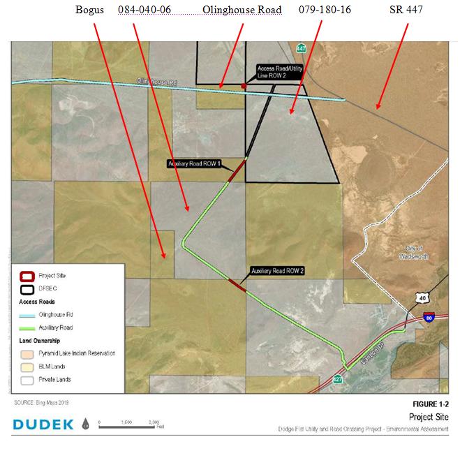
1. You might wonder what “Bogus” means. That rectangle is not BLM land. It is part of the privately owned parcel.
This is from the Washoe County database:
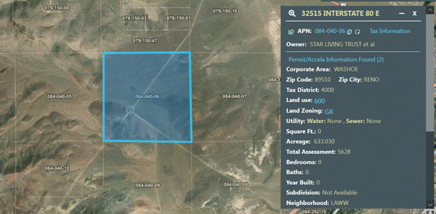
Why does NextEra Energy/Dudek want us to believe that the rectangle is BLM land?
2. NextEra Energy/Dudek says, “The existing road is currently used to access nearby mining operations, a natural gas line and associated facilities.”
The facilities associated with the natural gas pipeline is a Valve Shack (technically the Gas Transmission Interconnect Meter Station and Booster Unit Site) on 084-040-06..
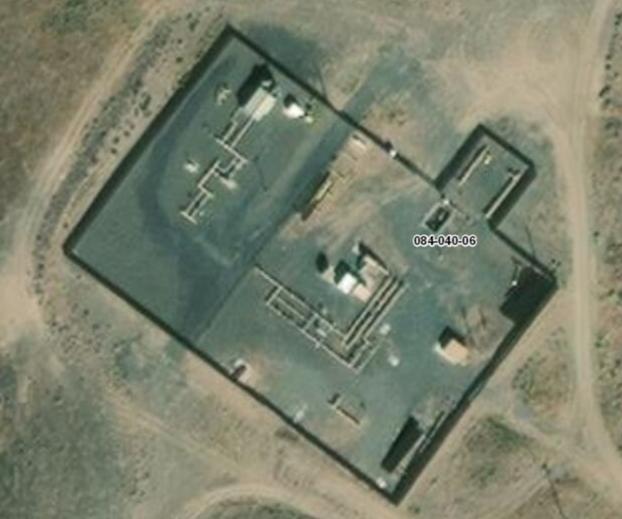
This is what it looked like from the ground in May 2013.
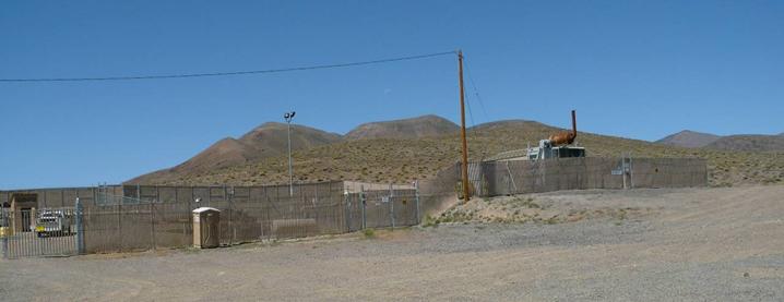
It might not look like much but there are pipes coming out of the ground.
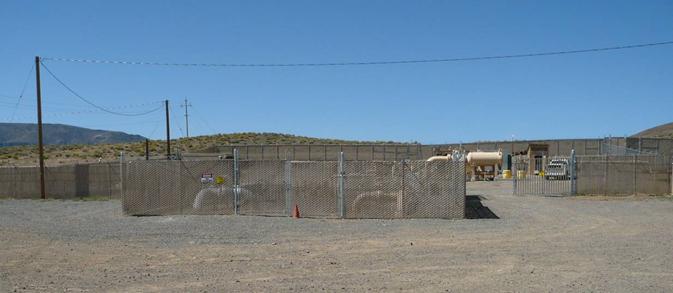
This was the sign by the road going to it:
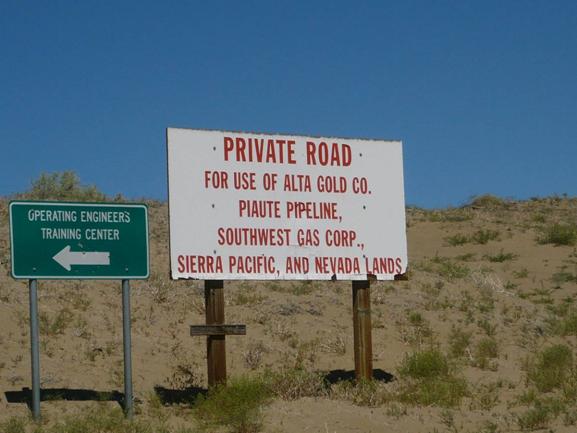
The Valve Shack is where the Tuscarora Pipeline (owned by TC Energy, which used to be called TransCanada Corporation) connects to the Southwest Gas pipeline.
Neither company owns the property. The property is now owned by Star Living Trust et al which is Fred Sadri’s Family Trust, Ray Koroghli’s Family Trust, and Reza Zandian (an individual against whom I have a Judgment.)
The Valve Shack, road, and pipeline are there because the Tuscarora Pipeline has an easement.
It wasn’t easy for Tuscarora to get the easement. They had to sue Nevada Land & Resource Company (then owned by Pico Holdings) which then owned the property. There were actually three lawsuits that were basically the same. For one of them Click Here. The lawsuits were settled with Tuscarora getting their easements (terms not disclosed). I say easements because it wasn’t just 084-040-06. It was also three other Pah Rah properties: 084-140-17, 084-040-10, and 084-130-07. Click Here.
The easement is for the underground pipeline, the above ground Valve Shack, and an access road.
The access road is for their use only. It is not a public road and is clearly posted as a private road.
Although NextrEra Energy said they were negotiating with the private landowners I do not see anything about an easement for 084-040-06 recorded. They would also need the permission of the Tuscarora Pipeline. After all, it is their road. By the terms of their easement the property owners can use the road but it doesn’t mean the property owners can let anyone else use it.
Did NextEra Energy use the road anyway?
Did they ever intend to use the road or were they just blowing smoke again?
Just like how they want people to believe that Olinghouse Road is not a public road.
They see easements as being malleable, to be bent and twisted however they see fit to achieve their purposes.
Let’s take a look at the Southern Access Utility Road from the other end, how the Southern Utility Access Road connects to I-80 by way of Cantlon Drive.
Going east on I-80 take Exit 43. Turn right onto Cantlon Drive.
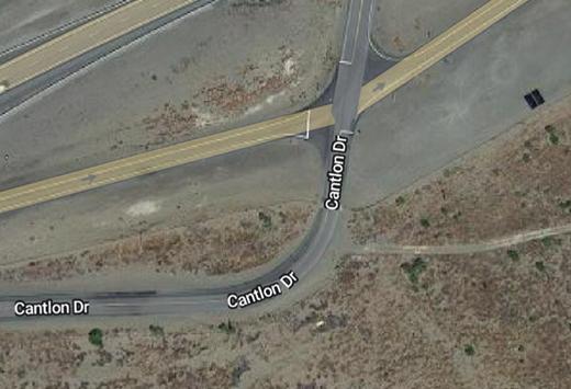
There is a sign that points to Cantlon Drive so you don’t have to guess.
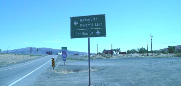
Once you get on Cantlon Drive you go a little ways until you see the sign that directs you to the Operating Engineers Training Center. You will be turning right soon.
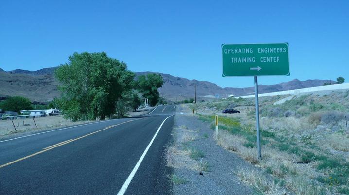
Who are the Operating Engineers and what is the Operating Engineers Training Center?
From: https://www.oe3.org/training-nevada/
We produce conscientious, skilled journey persons who are well-rounded and proficient in operating and maintaining heavy equipment and who have industry-related safety credentials.
To achieve this goal, we provide continuous learning opportunities for our apprentices and journey-level operators.
The Operating Engineers Training Center is where they train them. It is an apprenticeship program. They own 084-281-04 whose NE corner touches the SW corner of 084-040-08 which the Southern Access Utility Road goes through to get to Cantlon Drive.
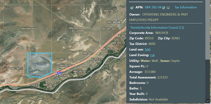
This is the Valve Shack.
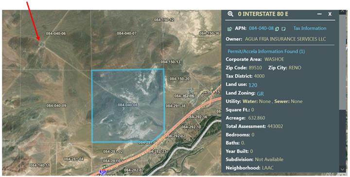
So, where were we?
We were on Cantlon Drive getting ready to turn right to get on the Southern Access Utility Road which also goes to the Operating Engineers Training Center.
We turn right and this is what we have to go through to get to the Southern Access Utility Road.
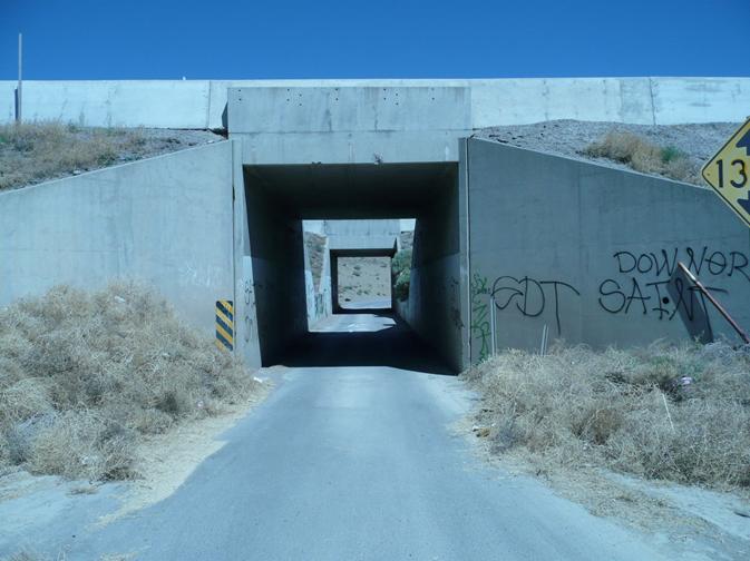
Oops.
This tunnel has two sections that go under I-80. One is under the eastbound lanes, the other is under the westbound lanes.
The clearance in the tunnel is 13’ 9”.
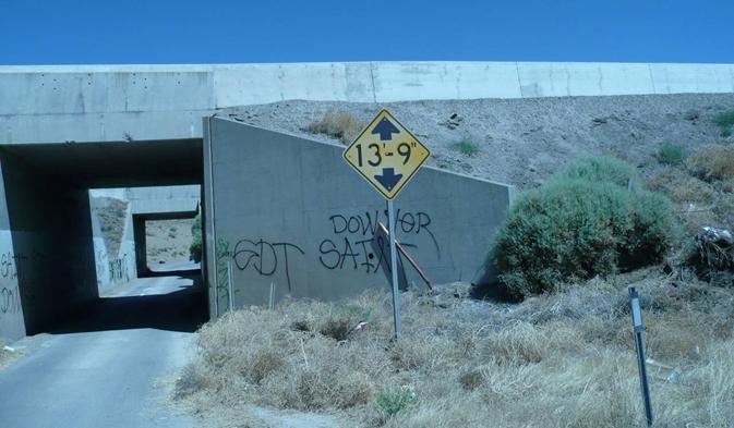
I measured the width of the tunnel with my tape measure and got 14’ 0”.
After you get through the tunnel you are now on the Southern Access Utility Road. which turns sharply to the left.
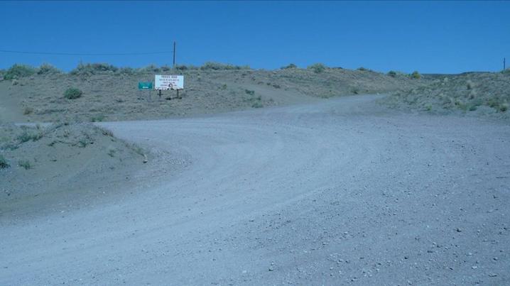
We have seen a sign like this before, only this one was used for target practice.
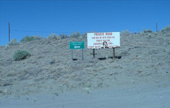
One of the juvenile delinquents used a pellet gun (or pellet rifle) and left behind a spent CO2 cartridge.
His fingerprints may still be on it. (Quick, somebody call CSI Washoe County.)
This tunnel is large enough for a concrete truck if the driver drives very slowly and is not claustrophobic or a flatbed truck that isn’t too long (same driver). That is because of the sharp left turn you have to make after the tunnel. Many semi trailers are both too high and too long.
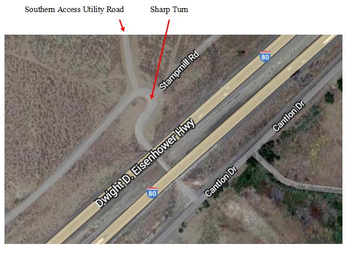
You would not be able to get a large bulldozer such as the popular Caterpillar D9 through the tunnel. It is 14.7’ wide at the blade. https://en.wikipedia.org/wiki/Caterpillar_D9
While it is possible to use this tunnel, only one vehicle can go through it at a time. And since the construction vehicles would be coming and going all day you would need flag-persons at each end.
So not only did NextEra Energy not get the easements they would have needed to use the Southern Access Utility Road as the alternate route they said it was, they failed to mention that the Southern Access Utility Road has this chokepoint.
BTW, it looks like someone didn’t believe the clearance is only 13’ 9” or they didn’t know how high their truck/load was.
The groove on the right made a real impression on the ceiling.
This requires maintenance for the safety of the tunnel. Over time the concrete will crumble away from the vibrations of the traffic above it, the gouge will widen and deepen, and eventually the tunnel will collapse. And there goes the eastbound lanes of I-80.
Here is a tip. If you have to go through a tunnel and your truck/load is too high by only an inch or two, let some air out of your tires until you will be able to clear the tunnel. After you get safely through the tunnel stop and re-inflate your tires. That assumes you have an air compressor that can inflate your tires. You should have one with you anyway. BTW, the cheap tire inflators for passenger cars probably won’t work for truck tires. Many of them won’t even work for passenger car tires. They are actually intended for bicycle tires. Read the box.
When the Europeans started coming to the Americas (and staying) in the 16th Century (notwithstanding that the Americas were already occupied by the Native Americans) Spain claimed huge areas of the Americas including what is now Mexico. That included a large part of what is now the Western United States.
Mexico fought for and won its independence from Spain in the Mexican War of Independence (1810 –1821).
As a result of the Mexican-American War (1846 - 1848) Mexico lost what are now the states of Texas, New Mexico, Arizona, California, part of Colorado, Utah, and Nevada.
When Nevada became a state in 1864 almost all of the state was owned by the U.S. Government (the Federal Government.) Even now 86% of the land in Nevada is still owned by the Federal Government.
When the Central Pacific Railroad put in its part of the Transcontinental Railroad part of its payment was land on either side of the track. This was in the form of a checkerboard of Federal land and land given to the Central Pacific. Over the next several decades the Central Pacific sold at least one of the parcels to a private individual but held on to most of it for the next 100+ years. Then they started dumping all of it.
Because water is critical for operating steam locomotives the last place to get it when you are going East before entering the 40-Mile Desert was where the Truckee River turns north to Pyramid Lake. It was at this turn that the Central Pacific set up the town of Wadsworth, which is on the Pyramid Lake Paiute Tribe Reservation.
When gold and other minerals were discovered west of Wadsworth (in the Pah Rah mountains) several mining claims were filed and this led to the establishment of the small town of Olinghouse. A post office was opened in 1898 and a small business district developed over the next decade, which included the usual mining camp accoutrements, such as saloons, restaurants and lodging houses. Olinghouse also had a courthouse, a justice of the peace, and a constable.
They had a road (Olinghouse Road) that went from Olinghouse to Wadsworth. Some of it went through Federal land, some through Central Pacific land. This was even before there was the current SR 447 highway or its predecessor highway SR 34. Part of Olinghouse Road became a segment of SR 34 (and then SR 447.)
When the U.S. Post Office Department opened its Ora Post Office in Olinghouse in 1898, Olinghouse Road became its Post Road.
A map prepared by the Nevada State Highway Department in 1947 shows the road from Olinghouse to SR 34 (now SR 447) as a “graded and drained road”. Click Here.
Washoe County maintained Olinghouse Road for several decades until, they claim, very recently. Washoe County published this map of Presumed Public Roads. It says: Original Date March 1999 / Revised October 2010.
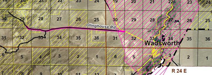
Olinghouse Road is solid black from Olinghouse to the border of the Pyramid Lake Paiute Tribe Reservation. It is also highlighted in pink from Olinghouse to SR 447 so Washoe County maintained it even if it is only a Presumed Public Road. Washoe County presumes it is all a public road.
Therefore, under NRS 405.191(1) it is a public road.
At a hearing held April 27, 1999, the Washoe County Board of County Commissioners found the roads shown on these maps were presumed to be public roads based on NRS 405.191 and NRS 405.195.
At that hearing Mr. David Roundtree, Public Works Director gave this testimony:
Mr. Roundtree noted that adoption of these roads and making them a part of the public record starts the statute of limitations, which in this case is 15 years; and that if a determination to the contrary is not made during that 15-year period, all roads shown on these maps actually do become public and there is then no opportunity for someone to challenge them.
The Washoe County Commissioners accepted his statement as fact even though there does not appear to be any statutory authority for it.
Nonetheless, if we add 15 years from 1999 we get 2014. Therefore, according to the Washoe County Commissioners, in 2014 Olinghouse Road officially became a public road and there is now no opportunity for someone to challenge it.
NRS 405.191(1) starts with:
NRS 405.191 “Public road” defined; county roads and highways may be established on rights-of-way over certain public lands. As used in NRS 405.193 and 405.195, “public road” includes:
1. A United States highway, a state highway or a main, general or minor county road and any other way laid out or maintained by any governmental agency.
It mentions NRS 405.195 . NRS 405.195 is about petitions to change the status of roads:
NRS 405.195 Petition to open, reopen, close, relocate or abandon road; hearings and orders by board of county commissioners regarding petition; legal actions authorized.
.....
2. Upon conclusion of the public hearing, the board shall determine whether the road in question has acquired the status of a public road because:
.....
(c) The right-of-way was:
.....
(2) Accepted by use as access to a mining claim or other privately owned property.
.....
There have been mining claims in Olinghouse since the 1890s.
NextEra Energy/Dodge Flat Solar wants people to believe that the segment of Olinghouse Road that is on the Pyramid Lake Paiute Tribe Reservation is not a public road by virtue of Dodge Flat Solar having purchased an easement from the Tribe.
Why did they buy an easement on what was already a public road?
The kindest explanation is that Olinghouse Road is nominally 25’ wide and they wanted to widen it to 60’ wide. Since they would be widening it onto Reservation land, that is why they needed an easement.
Or, they want people to think that Olinghouse Road is not a public road. They have already put in the Dodge Flat Solar farm and they want to do more. If the owners of the other properties can be convinced that their properties are not accessible by a public road then their properties are basically worthless. Then NextEra Energy can buy them cheap.
There is no evidence that Olinghouse Road was ever a toll road or was ever not a public road.
The segment of Olinghouse Road that goes through the Pyramid Lake Paiute Indian Reservation is a public road just as much as are the segments of SR 447, SR 446, and SR 445 that also go through the Reservation.
The evidence shows that Olinghouse Road is, and has always been, a public road all the way from Olinghouse to what is now SR 447.
Jed Margolin
Virginia City Highlands
Nevada
.end